RAF Beaulieu near East Boldre Walk
Walk 3542 - Route Maps
Route Map
Digital Maps - Copyright © 2011-2024. All rights reserved.
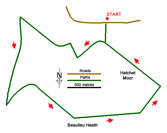
Sketch Map
Suggested Maps 

| Ordnance Survey Explorer OL22 | Sheet Map | 1:25k | BUY |
| Anquet OS Explorer OL22 | Digital Map | 1:25k | BUY |
It is recommended you take a map. The preferred scale is 1:25k.
Start Point Details
Ordnance Survey Grid Ref SU350019
Latitude 50.815596 Longitude -1.504556
Postcode SO42 7QL
what3words start salaried.asleep.newsstand
Walk description may contain detailed information on the start point for this walk.
Further Information
New Forest
The New Forest became a National Park in 2005, the first for many years and the first ever in South East England. Located between the urban areas of Southampton and Bournemouth it is bounded by the Solent. The National Park is dominated by open expanses of semi-natural vegetation including heathland, bogs, woodlands and streams. This environment is maintained through the grazing of thousands of New Forest ponies and cattle. New Forest Walking Guide
Walk grading - Learn how each walk is assessed and select a walk to suit your ability and experience by going to Walk Grading Details.
Messaging & Social Media
Message Walking Britain and follow the latest news.

Mountain Weather
Stay safe on the mountains with detailed weather forecasts - for iOS devices or for Android devices.