Shropshire Way at the Stiperstones National Nature Reserve
Walk Photo 187101
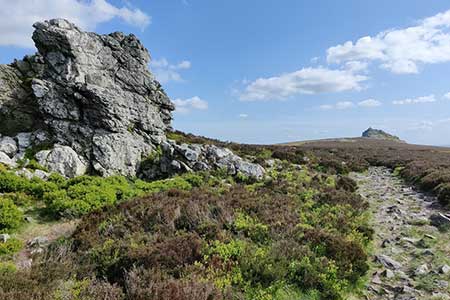
Caption - The rocks on the left are the Devil's Chair, with Manstone Rock in the distance. The Stiperstones is a hill in Shropshire. The quartzite rock of the ridge formed about 480 million years ago. During the last Ice Age, the Stiperstones lay on the eastern edge of the Welsh ice sheet. At 536 metres (1,759 ft) above sea level it is the second-highest hill in Shropshire. The Stiperstones are known for a series of tors of quartzite, there are six main tors, Shepherd's Rock, Devil's Chair, Manstone Rock, Cranberry Rock, Nipstone Rock and the Rock.
Walk 1871 : Snailbeach & the Stiperstones
Photographer : Mat Fascione
Use back button to return to the photo gallery lists.
Further Information
Location Map
Shropshire Hills
This National Landscape (formerly AONB) consists of a number of areas of hills centered on Church Stretton. The hills are known for the variety, extensive network of paths and wonderful scenery. The most popular hills are the Long Mynd but others including Wenlock Edge, the Stiperstones and those around Clun are also gaining in popularity. More Information
Messaging & Social Media
Message Walking Britain and follow the latest news.

Mountain Weather
Stay safe on the mountains with detailed weather forecasts - for iOS devices or for Android devices.