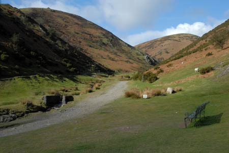
Haddon Hill and Bodbury Hill from Carding Mill Valley
Shropshire Hills Walk
Region - Shropshire Hills
County/Area - Shropshire
Author - Lou Johnson
Length - 4.4 miles / 7.2 km Ascent - 1200 feet / 364 metres
Time - 3 hours 20 minutes Grade - easy/mod
Maps 

| Ordnance Survey Explorer 217 | Sheet Map | 1:25k | BUY |
| Anquet OS Explorer 217 | Digital Map | 1:25k | BUY |
| Ordnance Survey Landranger 137 | Sheet Map | 1:50k | BUY |
| Anquet OS Landranger 137 | Digital Map | 1:50k | BUY |
Walk Route Description
Click image to visit gallery of 12 images.
The Long Mynd offers some fine walks and is a personal favourite of mine especially in the winter when the days are short. This route includes easy- to-follow paths in the initial stages, a section requiring some careful navigation and two steep descents in the second half of the walk.
The route starts in Carding Mill Valley. This popular "beauty spot" is well signed from Church Stretton and to make the best of your visit an early start to avoid the crowds is advised as parking can be at a premium later in the day. There is plenty of parking available either before the National Trust tea-room or you can drive as far as possible up the valley going past the tea-room to the small parking area (grid ref. SO441948). The whole of the valley is pay and display so don't forget to purchase your ticket.
After parking continue up the main valley path (ignoring the lesser path heading west up to the small reservoir). The path climbs steadily with steep grassy slopes on either side relieved by the occasional small rocky outcrop. Reaching a path junction (grid ref. SO435951) and continue the climb following Motts Road onto the main moorland ridge where you join a wider track running roughly northeast to southwest (grid ref. SO42695). Turn right and almost immediately half-right and aim for the green path heading for the summit of Haddon Hill (grid ref. SO435956).
From here there are excellent views which improve as you continue in roughly the same direction to reach the lower summit a little further on (grid ref. SO438953). Descend steeply in an easterly direction towards the gate giving access to the golf course. However do not go through the gate but follow the fence keeping it to your left. There is a feint path and you descend into a dip and climb back out to continue with the fence. You will see ahead and slightly to your right a clear path that follows the contours around Bodbury Hill. This is the next section of the route.
The steep drop off the path into Carding Mill Valley offers a bird's eye view of the café. Staying with the path you complete a 180 degree circuit to reach the fence again. Bear right and with the fence to your left follow the narrow path that runs alongside. The path descends very steeply alongside the fence which can be used to slow your downward progress! At the bottom you reach a wider path. Turn right and this leads you back into Carding Mill Valley. Continue up the road back to the start.
Other walks nearby
| Walk 3308 | Ragleth and the Long Mynd | mod/hard | 11.0 miles |
| Walk 3449 | Ragleth, the Long Mynd & Ratlinghope | hard | 18.0 miles |
| Walk 1374 | Lightspout Waterfall and Pole Bank | easy/mod | 5.8 miles |
| Walk 1321 | Caer Caradoc & Hope Bowder Hill | moderate | 9.0 miles |
| Walk 3048 | Caer Caradoc & The Lawley | moderate | 10.0 miles |
| Walk 1097 | Caer Caradoc | easy/mod | 3.5 miles |
| Walk 1844 | The Portway & Betchcott Hill from Picklescott | easy/mod | 5.0 miles |
| Walk 2745 | Betchcott Hills & Pole Bank | moderate | 9.0 miles |
| Walk 1205 | Adstone Hill, Medlicott and the Long Mynd | moderate | 9.5 miles |
| Walk 2054 | Linley Hill & Beeches from Wentnor | easy/mod | 7.0 miles |
Recommended Books & eBooks
Hillwalking in Shropshire
 Guidebook to 32 walking routes in Shropshire in the West Midlands. The routes range from 3 miles (5km) to 12 miles (19km), taking in highlights such as The Wrekin, Wenlock Edge, Long Mynd and Stiperstones, Castle Ring and Bury Ditches. Many routes start near delightful towns and villages including Church Stretton, Ludlow and Bishops Castle.
More information
Messaging & Social Media
Message Walking Britain and follow the latest news.

Mountain Weather
Stay safe on the mountains with detailed weather forecasts - for iOS devices or for Android devices.