Horseshoe Dale & Deep Dale from Wye Dale
Peak District Walk
Nat Park - Peak District - Bakewell Monsal Trail
County/Area - Derbyshire
Author - Lou Johnson
Length - 6.4 miles / 10.4 km Ascent - 900 feet / 273 metres
Time - 4 hours 10 minutes Grade - easy/mod
Maps 

| Ordnance Survey Explorer OL24 | Sheet Map | 1:25k | BUY |
| Anquet OS Explorer OL24 | Digital Map | 1:25k | BUY |
Walk Route Description
Click image to see photo description.
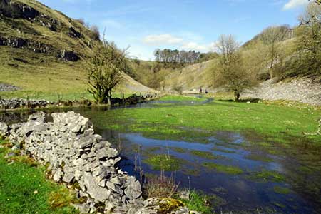
This Peak district walk features three dales, a section of the limestone upland and the village of Chelmorton. The route follows good paths and tracks including part of the Pennine Bridleway. This route also passes an area of narrow walled fields to the west of Chelmorton.
The start is the free car park in Wye Dale (grid ref. SK104725) on the north side of the A6 5 miles west of Buxton. After parking walk east following the sign 'Bridleway to Monsal Trail'. Continue beside the River Wye, ignoring the signed 'walking route to Monsal Trail' on the right. Continue to the Blackwell Mill Cycle Centre and just after turn right following the Pennine Bridleway sign. Pass through a gate, turn left and then go right up steps to reach a stile. Pass a Cheedale Nature Reserve board and follow path steeply uphill following the Pennine Bridleway.
At the top of the dale (grid ref. SK115723) bear left and follow the path, which becomes a track, for 800 metres to reach a lane in Blackwell. Turn right still on the Bridleway and continue to the A6. Go straight across and follow the lane uphill. Continue around a right-hand bend and take the first bridleway on the left (grid ref. SK1237130). Follow the walled track south for 700 metres to reach a tarmac lane. Take the first path on the right by a three-way fingerpost to Chelmorton. Just past the church on your left, turn left into the village. Pass the Church In on your right and continue downhill to the first fingerpost on your right near a wooden bench (grid ref. SK115702).
Follow the clear track keeping to the left at Shepley Farm. 250 metres beyond the farm entrance turn left along a walled track. Cross a lane and continue south for 250 metres to where the track turns sharp right. On the corner (grid ref. SK 108701) take the footpath from the corner half-left across a field to re-join a walled track. Follow the walled track to the A5270. Bear left passing a sewage works on your right and continue for 100 past the entrance. Turn right onto a path (hidden in bushes) into a field. Walk half left across the field and continue into a smaller field keeping to the left of a broken-down wall to re-join the A5270. If you fail to the find this path, follow the A 5270, which has a grass verge to pass Dale Grange Farm.
If you have found the path, turn right along the A5270, pass Dale Grange Farm and after 120 metres turn right onto a footpath through a gate between trees (easily missed). Follow the path to a group of barns, Ignore the metal on your left and bear right through a wooden gate to enter Horseshow Dale. The follows the foot of the dale veering left and then right to reach an information board and stile when you enter Deep Dale (grid ref. SK096708). Stay in the bottom of the dale. The path, rough in places, enters trees, and crosses the Midshires Way. Shortly after leaving the trees, cross a stile with adjacent gate. Continue along a gravel track past warning signs. Bear left, descend some steps and soon after join a narrow path. Continue pass the entrance to the quarry and walk on path beside the road. Cross the A6, with care, and return to the car park opposite.
Other walks nearby
| Walk 1859 | Chee Dale & Monk's Dale from Miller's Dale | moderate | 7.3 miles |
| Walk 1852 | Eldon Hill from Peak Forest | easy/mod | 5.0 miles |
| Walk 1043 | Chelmorton & the Monsal Trail | easy/mod | 8.1 miles |
| Walk 1650 | Miller's Dale & Cressbrook Dale from Tideswell Dale | easy/mod | 5.5 miles |
| Walk 1206 | Chelmorton & Flagg from Taddington | easy/mod | 6.0 miles |
| Walk 2573 | Tideswell, Miller's & Cressbrook Dales from Litton | easy | 7.0 miles |
| Walk 2635 | The edges of Combs Moss near Chapel-en-le-Frith | easy/mod | 7.5 miles |
| Walk 1651 | Monsal Trail & Ashford-in-the-Water from Lees Bottom | easy/mod | 8.8 miles |
| Walk 3341 | Brushfield, Miller's Dale & Monsal Head from Lees Bottom | easy/mod | 6.5 miles |
| Walk 2522 | Rushup Edge & Edale from Mam Nick | moderate | 7.0 miles |
Recommended Books & eBooks
Dark Peak Walks
 Guidebook to 40 walks in the Dark Peak area of the Peak District National Park. 35 circular routes for most abilities, from 8km to 19km, around Edale, Marsden, Fairholmes, Baslow and Castleton, including Kinder Scout and Mam Tor, and 5 longer (25km to 45km) routes highlighting the best of the Gritstone Edges, High Moorland and Deep Valleys.
More information
Great Mountain Days in the Pennines
 An inspirational guidebook to 50 classic walks on the rolling Pennine landscape. The graded routes, between 6 and 13 miles in length, cover classic Pennine fells and moorland such as Whernside, Ilkley Moor and Pendle Hill; exploring the North and South Pennines, Yorkshire Dales, Howgills and Dark Peak. Many routes are also suited to fell running.
More information
Messaging & Social Media
Message Walking Britain and follow the latest news.

Mountain Weather
Stay safe on the mountains with detailed weather forecasts - for iOS devices or for Android devices.