Porthcothan to Watergate Bay
Cornwall Walk
County/Area - Cornwall
Author - Lou Johnson
Length - 6.8 miles / 11.1 km Ascent - 1200 feet / 364 metres
Time - 4 hours 40 minutes Grade - easy/mod
Maps 

| Ordnance Survey Explorer 106 | Sheet Map | 1:25k | BUY |
| Anquet OS Explorer 106 | Digital Map | 1:25k | BUY |
Walk Route Description
Click image to see photo description.
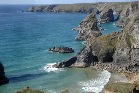
This linear walk from Porthcothan follows the South West Coast Path along the north Cornwall coast to Watergate Bay. The route passes sandy beaches, rocky headlands and includes the Bedruthan Steps. The route follows a good path and depending on season you are likely to encounter varied wildlife. Unlike some sections of coastal walking there are many choices of refreshments along the way.
The walk starts from Watergate Bay from where a bus, route 56 to Padstow, is used to reach Porthcothan. There are two car parks close to the bus stop (grid ref. SW843649). After parking catch the bus from near the public toilets. The journey time to Porthcothan is about 30 minutes and you should alight at the bus top near the entrance to the main car park (grid ref. SW858720). The path is waymarked with an Acorn symbol.
After arrival take the South West Coast Path along a track signed by the telephone box opposite the car park entrance. Initially the path runs along the beach (on your right) before turning south passing Trescore Islands on your right. The path descends into a valley, crosses a footbridge, and then climbs up to Park Head. The path veers left along the cliffs passing several rock formations including Pentire Steps, Queen Bess Rock, Samaritan Island and Bedruthan Steps.
Beyond Bedruthan Steps a short diversion to the left leads to a National Trust tearoom at Carnewas (grid ref. SW850690). The next landmark is Trenance Point where the path reaches its maximum height above the sea. Continue downhill towards the sands of Mawgan Porth. Just before the beach cross a footbridge before continuing along the clifftop path before descending steps onto the beach. Continue along the beach to exit onto a road in Mawgan Porth.
Turn right across the bridge, and then take the first footpath on the right (signed Watergate) still following the South West Coast Path. The route rounds two headlands before the sands of Watergate Bay come into view. Continue to reach Trevarrian Hill in Watergate Bay. Turn right downhill back to the start.
Other walks nearby
| Walk 1547 | Trevose Head & Constantine Bay from Porthcothan | easy/mod | 8.5 miles |
| Walk 3589 | Padstow from Little Petherick | easy | 5.0 miles |
| Walk 3738 | Polzeath & Pentire Point from Rock | moderate | 11.4 miles |
| Walk 1104 | Newquay to Porthcothan coast path | moderate | 10.5 miles |
| Walk 2462 | The Rumps & Pentire Point | easy/mod | 4.0 miles |
| Walk 3264 | Port Quin & Port Isaac Circular | easy/mod | 5.7 miles |
| Walk 1029 | Tintagel to Boscastle | moderate | 9.0 miles |
| Walk 1883 | Advent Church | easy | 5.2 miles |
| Walk 2294 | St. Agnes to Porthtowan | easy/mod | 5.0 miles |
| Walk 1808 | Brown Willy, exploring Cornwall's highest Tors | easy/mod | 4.0 miles |
Recommended Books & eBooks
South West Coast Path Map Booklet - Minehead to St Ives
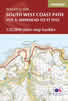 Map of the northern section of the 630 mile (1014km) South West Coast Path National Trail. Covers the trail from Minehead to St Ives along the north Devon and Cornish coastline. This convenient and compact booklet of Ordnance Survey 1:25,000 maps shows the route, providing all of the mapping you need to walk the trail in either direction.
More information
Walking in Cornwall
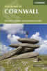 This guidebook includes routes to 40 day walks in Cornwall. From short, easy strolls to longer, wilder routes, there is plenty to appeal to both families and experienced walkers. The walks explore the interior and coasts, including walks through picturesque villages, old tin-mining areas and the Lizard and Land's End Peninsulas.
More information
Messaging & Social Media
Message Walking Britain and follow the latest news.

Mountain Weather
Stay safe on the mountains with detailed weather forecasts - for iOS devices or for Android devices.