Abbotstone from Old Alresford
Hampshire Walk
County/Area - Hampshire
Author - Lou Johnson
Length - 5.1 miles / 8.3 km Ascent - 420 feet / 127 metres
Time - 3 hours 0 minutes Grade - easy
Maps 

| Ordnance Survey Explorer OL32 | Sheet Map | 1:25k | BUY |
| Anquet OS Explorer OL32 | Digital Map | 1:25k | BUY |
Walk Route Description
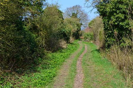
Click image to see photo description.
This circular walk from Old Alresford explores the downs north of the village using tracks and paths across the rolling countryside. Alresford has been famous for watercress which has been cultivated in the chalk streams. The arrival of the railway meant that the crop could be in the London markets the following morning and commercial growing boomed. This walk passes several of the cress beds.
The start is the centre of Old Alresford where parking is available near the Christy Hall and telephone box (grid ref. SU588341). After parking, and with your back to the Hall, turn right along a road beside the green. Follow the road around to the right and then left into a signed private road. Continue ahead to the end of the tarmac and take the footpath between hedges. Continue across two fields keeping to the left-hand hedge. Exit the second field and join a clear track to a lane (grid ref. SU583333).
Turn right and after 200 metres turn left onto a footpath through a gap in a hedge. Cross the lawn into a field and turn left keeping the hedge on your left. The path soon turns right and continues ahead to reach Keepers Cottage and a tarmac drive. Follow the path alongside the drive to a road (grid ref. SU577330). Cross the road and take the signed path across a field (hedge right) to a lane. Turn left along the lane (part of the Oxdrove Way). After 350 metres turn left onto a track just past a large barn. Follow the track into the valley After 250 metres you reach a junction of tracks. Bear right here and ascend gently out of the valley to a lane (grid ref. SU560339).
Cross the lane and continue ahead on rising tree lined track. After 600 metres you reach a five-way junction of paths (grid ref. SU556343) on Itchen Stoke Down. Turn right and descend to a lane. Continue ahead keeping the grassy triangle on your left. Follow the lane to the next junction at Abbotstone where you continue ahead uphill. Nearing the top of the hill, ignore the first track on the left, and then take the next track on the left (grid ref. SU566345). The track soon enters trees where the route turns right between hedges. Keep ahead on this track ignoring all tracks on the right. A final descent leads to the road used at the beginning of the walk. Follow the road around to the left and back to the start in Old Alresford.
Other walks nearby
| Walk 3324 | Cheriton Mill & Tichborne from Cheriton | easy | 5.7 miles |
| Walk 2459 | Upper Wield & Godsfield Circular | easy/mod | 6.7 miles |
| Walk 1128 | Bradley & Burkham Circular | easy | 5.5 miles |
| Walk 1034 | Beacon and Old Winchester Hills on the South Downs | moderate | 10.5 miles |
| Walk 2383 | Upham & Owslebury Circular | easy/mod | 6.5 miles |
| Walk 2662 | Beacon Hill and Warnford | easy/mod | 6.0 miles |
| Walk 2710 | Old Winchester Hill from Exton | easy/mod | 5.5 miles |
| Walk 3693 | Alton to Farnham using St Swithun's Way | moderate | 12.0 miles |
| Walk 2533 | East Meon to Old Winchester Hill | moderate | 12.0 miles |
| Walk 2394 | East Meon & Wether Down | easy/mod | 8.0 miles |
Recommended Books & eBooks
Walking Hampshire's Test Way
 Guidebook to walking the 71km (44 mile) Test Way in Hampshire from high on the chalk downs of Inkpen Beacon to the Eling Tide Mill near Southampton Water. Following the beautiful, crystal clear River Test, it passes picturesque villages and fascinating historic sites. Also includes 15 day walks to explore this lovely part of pastoral England.
More information
Messaging & Social Media
Message Walking Britain and follow the latest news.

Mountain Weather
Stay safe on the mountains with detailed weather forecasts - for iOS devices or for Android devices.