Upper Wield & Godsfield Circular
Countryside Walk
County/Area - Hampshire
Author - Lou Johnson
Length - 6.7 miles / 10.9 km Ascent - 450 feet / 136 metres
Time - 3 hours 50 minutes Grade - easy/mod
Maps 

| Ordnance Survey Explorer OL32 | Sheet Map | 1:25k | BUY |
| Anquet OS Explorer OL32 | Digital Map | 1:25k | BUY |
Walk Route Description
Click image to see photo description.
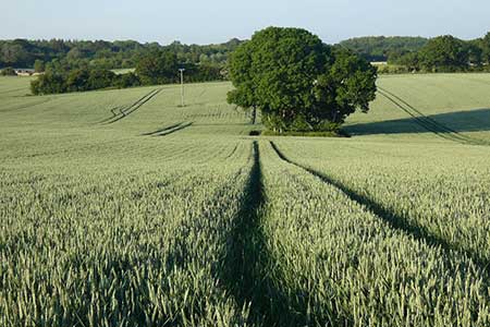
Starting from the attractive village of Upper Wield, this walk explores the undulating countryside southwest of the village. The route follows the Oxdrove Way before continuing through Godsfield to join the Three Castles Path back to the start. Limited parking is available near the telephone box by the small village green (grid ref. SU630387).
After parking, take the road signed to Preston Condover. After 120 metres, turn left in front of a thatched cottage and continue to the end of the road. Continue ahead along a track into a field and immediately head half-left across the field. Entering the next field the path heads half right before running beside Barton Copse to exit onto a road (grid ref. SU623379). Turn right along the road and at the next junction turn left. The road soon bends left so keep ahead onto a clear track (the Oxdrove Way) with a fingerpost on the right.
Follow the clear track, which after 350 metres bends right. Reaching Upper Lanham Farm, continue ahead along the track. For the next section, the track runs between trees with short sections through woodland. Continue for 1.8 kilometres to a fingerpost on the right. This is 300 metres before a lane. The path runs across a field veering away from the left-hand field edge to a kissing gate. Walk ahead to another gate and turn left along the driveway from Lower Lanham to a road.
Turn right and at the next junction fork left signed to Godsfield Manor. The lane leads past Godsfield Chapel on your right and then Godsfield Farm also on your right. 200 metres beyond the farm, the track bends right, passes houses on your right and leads into open countryside with a hedge on your left. After 400 metres (at the end of the first field) turn right onto the Three Castle Walk. The onward route passes to the right of Godsfield Copse. After passing a strip of woodland on your left the path doglegs left and right to continue into Wield Wood (grid ref. SU609382). Stay on the track for a further two kilometres to re-join the outward route. Continue ahead along a residential road and turn right at the first junction to return to the start by Lower Wield green and phone box.
Other walks nearby
| Walk 1128 | Bradley & Burkham Circular | easy | 5.5 miles |
| Walk 1964 | Abbotstone from Old Alresford | easy | 5.1 miles |
| Walk 3693 | Alton to Farnham using St Swithun's Way | moderate | 12.0 miles |
| Walk 1025 | Farleigh Wallop and Ellisfield | easy/mod | 6.5 miles |
| Walk 3324 | Cheriton Mill & Tichborne from Cheriton | easy | 5.7 miles |
| Walk 1726 | Weston Corbett from Upton Grey | easy | 5.6 miles |
| Walk 1976 | Noar Hill from Selborne | easy/mod | 5.0 miles |
| Walk 1034 | Beacon and Old Winchester Hills on the South Downs | moderate | 10.5 miles |
| Walk 2165 | Overton & the Harroway | easy | 4.3 miles |
| Walk 2533 | East Meon to Old Winchester Hill | moderate | 12.0 miles |
Recommended Books & eBooks
Walking Hampshire's Test Way
 Guidebook to walking the 71km (44 mile) Test Way in Hampshire from high on the chalk downs of Inkpen Beacon to the Eling Tide Mill near Southampton Water. Following the beautiful, crystal clear River Test, it passes picturesque villages and fascinating historic sites. Also includes 15 day walks to explore this lovely part of pastoral England.
More information
Messaging & Social Media
Message Walking Britain and follow the latest news.

Mountain Weather
Stay safe on the mountains with detailed weather forecasts - for iOS devices or for Android devices.