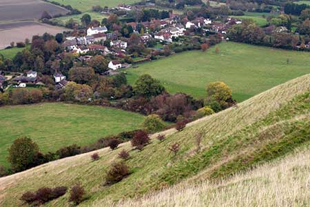
Edburton Hill from Fulking
South Downs Walk
Nat Park - South Downs
County/Area - West Sussex
Author - Lou Johnson
Length - 6.1 miles / 9.9 km Ascent - 850 feet / 258 metres
Time - 3 hours 50 minutes Grade - easy/mod
Maps 

| Ordnance Survey Explorer 122 | Sheet Map | 1:25k | BUY |
| Anquet OS Explorer 122 | Digital Map | 1:25k | BUY |
Walk Route Description
Click image to see photo description.
A circular walk from the village of Fulking which lies at the foot of the northern escarpment of the South Downs. The route initially follows field paths before passing through Longlands Wood. The walk turns south and after a steep climb reaches the top of the escarpment and the South Downs Way. Turning east the walk follows this National Trail over Truleigh Hill and Edburton Hill which both offer excellent views. A final ascent over Perching Hill before a steep descent down to Fulking.
The start is a layby (grid ref. TQ247114) near the Shepherd and Dog Public House in Fulking. After parking walk past the pub (on your right) and turn left onto the footpath just before a thatched cottage on the left. Keep to the right of the first small field. In the next field the path heads half left and maintains direction across two fields to cross a track (perching Drove). Continue half right across the field aiming for the right-hand corner of a wood (grid ref. TQ241120).
Bear left along the edge of the wood, go straight across the track and follow the onward path with a hedge on your left to reach a track. Turn left briefly and then right keeping to the left-hand side of the field. Pass through trees and continue ahead with houses on your left. Entering a large field keep to the right-hand edge and continue to a track (grid ref. TQ225120). Go straight across and continue with the hedge on your right to enter Longlands Wood. Continue ahead, ignoring side tracks, to reach a four-way fingerpost (grid ref. TQ219122) where you turn left to follow a track that leads to Tottington Manor Farm. Follow the right of way through the farm to Edburton Road (grid ref. TQ216115).
Turn right and take the first footpath on the left. The path climbs steeply in an arc onto Tottington Mount. Reaching a bridleway, turn left to reach the South Downs Way (grid ref. TQ219104). Turn left and continue over Truleigh Hill with its radio station. A descent and short climb lead to Edburton Hill. Another descent followed by a short ascent leads to the top of Perching Hill (grid ref. TQ244109). The path descends and after 250 metres from the summit you reach a dip in the path (grid ref. TQ247109). Bear half right off the South Downs Way down a track which descends steeply. After 300 metres you reach a complex junction of paths and tracks. Bear half-left and follow a grassy path downhill to the north. Reaching a cross track, turn right to reach Poynings Road. Turn left and at the next junction turn left again through Fulking village back to the start.
Other walks nearby
| Walk 3488 | Devil's Dyke Circular | easy | 2.5 miles |
| Walk 3487 | Edburton Hill & Devil's Dyke from Saddlescombe | hard | 10.5 miles |
| Walk 3213 | Pyecombe, Devil's Dyke & Upper Beeding | easy/mod | 8.0 miles |
| Walk 2109 | Upper Beeding to Washington by the South Downs Way | easy/mod | 7.0 miles |
| Walk 2236 | Wolstonbury Hill and Pyecombe from Patcham | moderate | 11.0 miles |
| Walk 1782 | Steyning Round Hill and No Man's Land | moderate | 7.5 miles |
| Walk 1858 | Cissbury Ring and Chanctonbury Ring | moderate | 10.5 miles |
| Walk 1888 | Cissbury Ring, Chanctonbury Ring & Coombes | moderate | 12.5 miles |
| Walk 2903 | Stanmer to Streat | moderate | 12.5 miles |
| Walk 2684 | Falmer to Pyecombe & Blackcap by South Downs Way | moderate | 8.8 miles |
Recommended Books & eBooks
The South Downs Way
 Guidebook to walking the South Downs Way National Trail, a 100 mile (160km) route between Winchester and Eastbourne through the South Downs National Park, described in both directions over 12 stages. Easy walking on ancient and historical tracks, taking in wooded areas, delightful river valleys and pretty villages. With 1:25K OS map booklet.
More information
Walks in the South Downs National Park
 Guidebook with 40 circular walks throughout the South Downs National Park, exploring the beautiful chalk hills between Eastbourne and Winchester. The walks range from under 5 miles to 11 miles, including Beachy Head and the Seven Sisters, Ditchling Beacon and hundreds of prehistoric sites. Accessible all year, but wild flowers best in spring.
More information
Messaging & Social Media
Message Walking Britain and follow the latest news.

Mountain Weather
Stay safe on the mountains with detailed weather forecasts - for iOS devices or for Android devices.