Walk 2096 - printer friendly version
Alton Water, Stutton & Tattingstone Walk
Author - Lou Johnson
Length - 5.5 miles / 8.9 km
Ascent - 200 feet / 61 metres
Grade - easy
Start - OS grid reference TM140364
Lat 51.9848170 + Long 1.1150505
Postcode IP9 2EJ (approx. location only)
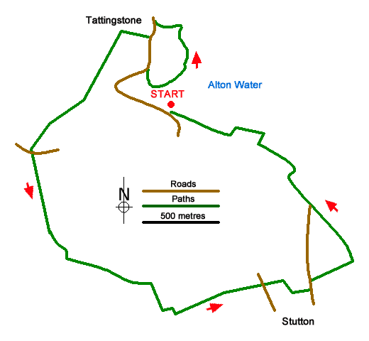
This Suffolk walk starts from the western side of Alton Water and follows the shoreline north to Tattingstone. Turning inland the route uses field paths and tracks to reach Stutton from where the walk turns north back to the shores of Alton Water. Close to the start is the Wonder folly which from the rear looks like a pair of cottages but from the front a church with a tower.
The start is The Wonder pay and display car park (grid ref. TM140364). After parking locate the cycleway and footpath close to the reservoir and turn west with the water on your right. Continue along the clear path for 1.5 kilometres to pass close to Tattingstone Place (on your left). Reaching the Dorothy Wright memorial bench, continue for 25 metres, cross the stile on the left and follow the path towards the village. Reaching a road (grid ref. TM138371), turn left and follow Church Road south around a right-hand bend. Just as the road bends left, turn right along a track (Back Lane).
After 200 metres turn left onto a signed footpath opposite a road on the right. The path initially heads half-right across a field and then maintains direction across four fields to reach Stutton Lane (grid ref. TM128361). Go straight ahead along Vale Lane and continue to Vale Farm where the path bears left off the farm's drive. Follow the waymarked path beside a plantation and cross a field. Reaching a track with a pond ahead, bear right and continue along the clear track to join tarmac Lewis Lane (grid ref. TM138349). After passing a pink bungalow, take the first signed path through a hedge on the left (grid ref. TM140348). If you reach another bungalow, you have gone too far. Follow the path along the right-hand side of a field.
At the end of the field continue ahead into Woodfield Lane. Reaching a T-junction, turn left almost immediately right onto a signed footpath. At the end of the first field, ignore the footpath heading left and continue into the next field following the path alongside the right-hand edge. Reaching a lane, turn left and then take the first signed footpath on the right. Again, the path the right-hand edge of a field. At the end of the field turn left again keeping the filed edge and continue through a gap in the hedge onto a clear track. Stay on the track for two kilometres to return to the car park.
Messaging & Social Media
Message Walking Britain and follow the latest news.

Mountain Weather
Stay safe on the mountains with detailed weather forecasts - for iOS devices or for Android devices.