Alton Water, Stutton & Tattingstone
Suffolk Walk
County/Area - Suffolk
Author - Lou Johnson
Length - 5.5 miles / 8.9 km Ascent - 200 feet / 61 metres
Time - 3 hours 0 minutes Grade - easy
Maps 

| Ordnance Survey Explorer 197 | Sheet Map | 1:25k | BUY |
| Anquet OS Explorer 197 | Digital Map | 1:25k | BUY |
Walk Route Description
Click image to see photo description.
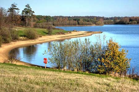
This Suffolk walk starts from the western side of Alton Water and follows the shoreline north to Tattingstone. Turning inland the route uses field paths and tracks to reach Stutton from where the walk turns north back to the shores of Alton Water. Close to the start is the Wonder folly which from the rear looks like a pair of cottages but from the front a church with a tower.
The start is The Wonder pay and display car park (grid ref. TM140364). After parking locate the cycleway and footpath close to the reservoir and turn west with the water on your right. Continue along the clear path for 1.5 kilometres to pass close to Tattingstone Place (on your left). Reaching the Dorothy Wright memorial bench, continue for 25 metres, cross the stile on the left and follow the path towards the village. Reaching a road (grid ref. TM138371), turn left and follow Church Road south around a right-hand bend. Just as the road bends left, turn right along a track (Back Lane).
After 200 metres turn left onto a signed footpath opposite a road on the right. The path initially heads half-right across a field and then maintains direction across four fields to reach Stutton Lane (grid ref. TM128361). Go straight ahead along Vale Lane and continue to Vale Farm where the path bears left off the farm's drive. Follow the waymarked path beside a plantation and cross a field. Reaching a track with a pond ahead, bear right and continue along the clear track to join tarmac Lewis Lane (grid ref. TM138349). After passing a pink bungalow, take the first signed path through a hedge on the left (grid ref. TM140348). If you reach another bungalow, you have gone too far. Follow the path along the right-hand side of a field.
At the end of the field continue ahead into Woodfield Lane. Reaching a T-junction, turn left almost immediately right onto a signed footpath. At the end of the first field, ignore the footpath heading left and continue into the next field following the path alongside the right-hand edge. Reaching a lane, turn left and then take the first signed footpath on the right. Again, the path the right-hand edge of a field. At the end of the field turn left again keeping the filed edge and continue through a gap in the hedge onto a clear track. Stay on the track for two kilometres to return to the car park.
Other walks nearby
| Walk 2374 | Freston Circular | easy/mod | 6.6 miles |
| Walk 3658 | Manningtree, Flatford Mill and Dedham | easy/mod | 7.1 miles |
| Walk 3660 | Stour Valley & Dedham from Flatford Mill | easy | 3.5 miles |
| Walk 2017 | Pin Mill to Shotley Gate | easy | 5.5 miles |
| Walk 1639 | Erwarton, Church End & River Orwell from Pin Mill | easy/mod | 8.0 miles |
| Walk 3642 | Shotley Gate & Ewarton from Chelmondiston | moderate | 10.6 miles |
| Walk 1648 | Church End & Erwarton from Shotley Gate | easy | 6.0 miles |
| Walk 3724 | River Box from Stoke-by-Nayland | easy | 6.0 miles |
| Walk 3267 | Ramsholt, River Deben and Shottisham Circular | easy/mod | 9.2 miles |
| Walk 2366 | The Naze from Walton-on-the-Naze | easy | 6.0 miles |
Recommended Books & eBooks
Suffolk Coast and Heath Walks
 Guidebook to three long-distance routes exploring the varied landscapes of the Suffolk Coast and Heaths AONB. The Suffolk Coast Path covers 55 to 60 miles from Lowestoft to Felixstowe. The Stour and Orwell Walk is 40 miles from Felixstowe to Cattawade near Manningtree, while the Sandlings Walk is 59 miles from Ipswich to Southwold.
More information
Messaging & Social Media
Message Walking Britain and follow the latest news.

Mountain Weather
Stay safe on the mountains with detailed weather forecasts - for iOS devices or for Android devices.