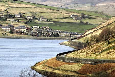
Marsden Moor from Marsden
South Pennines Walk
Nat Park - Peak District - Black Hill Dovestone
Region - South Pennines
County/Area - West Yorkshire
Author - Lou Johnson
Length - 6.4 miles / 10.4 km Ascent - 1000 feet / 303 metres
Time - 4 hours 10 minutes Grade - easy/mod
Maps 

| Ordnance Survey Explorer OL1 | Sheet Map | 1:25k | BUY |
| Anquet OS Explorer OL1 | Digital Map | 1:25k | BUY |
| Ordnance Survey Explorer OL21 | Sheet Map | 1:25k | BUY |
| Anquet OS Explorer OL21 | Digital Map | 1:25k | BUY |
Walk Route Description
Click image to see photo description.
This West Yorkshire walk from Marsden explores the reservoirs and moorland lying south of the village. The route follows good paths and tracks and uses sections of the Kirklees Way, Pennine Way and Standedge Trail. The walk passes through typical South Pennine scenery with deep valleys cut into the moorland.
The start is the Standedge Visitor Centre Car Park (Grid ref. SE047118) in the old railway goods yard, a site that also houses the National Trust centre for the Marsden Moor Estate. The car park is close to Marsden Railway Station and local bus services. After parking exit the car park and turn left downhill into the village. At the first junction fork right along Church Lane passing the church on your right. Where Church Lane bends right, continue ahead into Fall Lane and soon pass under a bridge. Continue ahead passing a sports ground on your left to reach a roundabout. Cross straight over and past a post box. Take the first cobbled lane on the right (with footpath sign to Wessenden Valley nearby). You are now following the Kirlees Way.
Continue ahead ignoring a footbridge on the right and climb the steps to the top of Butterley Reservoir Dam (grid ref. SE049106). A good track leads along the east bank of the reservoir. After just over a kilometre, you reach Blakeley Reservoir. Continue along the clear track to just beyond the reservoir and a path junction with fingerpost (grid ref. SE054091). Turn right onto the Pennine Way. The path drops down to cross a river and then climbs steadily onto the moor up Blakeley Clough. You soon pass Swellands Reservoir down to your right before following the shoreline of Black Moss Reservoir. The path then descends towards Redbrook Reservoir to reach a path junction (grid ref. SE027094).
Turn right along the Standedge Trail, a grassy track which descends across the moor to reach Mount Road (grid ref. SE037101). Turn right and then fork left up Old Mount Road. After 50 metres fork left up a track with adjacent finger post. Continue for just under a kilometre along the track and then bear right down to a small wooden gate with adjacent NT Marsden Moor sign. Pass through the gate (grid ref. SE041108) and follow the path downhill with a wall on your right. Reaching Old Mount Road, turn left and descend into Marsden. Cross the A62 with care and take the road opposite which leads into Church Lane. Pass the church on your left and turn left at the next junction. Continue uphill back to the start.
Other walks nearby
| Walk 2613 | Boundary Walk from Marsden | moderate | 13.0 miles |
| Walk 1587 | Scammonden Reservoir | easy | 4.0 miles |
| Walk 2561 | Digley & Ramsden Reservoirs from Wessenden Head | moderate | 9.5 miles |
| Walk 2719 | Huddersfield's green fringe | easy/mod | 10.0 miles |
| Walk 2518 | Black Hill & Four Reservoirs from near Wessenden Head | moderate | 10.0 miles |
| Walk 1586 | Blackmoorfoot Reservoir | easy | 1.5 miles |
| Walk 2914 | The Pots & Pans from Uppermill | easy/mod | 4.5 miles |
| Walk 2634 | Broadstone Hill & the Cotton Famine Road | moderate | 7.0 miles |
| Walk 1583 | Digley Reservoir | easy/mod | 5.0 miles |
| Walk 1091 | Ripponden and the Calderdale Way | easy/mod | 6.5 miles |
Recommended Books & eBooks
The Pennine Way
 Guidebook to the Pennine Way National Trail with OS map booklet. The 265 mile route from Edale to Kirk Yetholm takes three weeks to walk and is suitable for fit and experienced long distance walkers. The route crosses the Peak District, Yorkshire Dales and North Pennines National Parks. Includes separate OS 1:25,000 map booklet of the route.
More information
Dark Peak Walks
 Guidebook to 40 walks in the Dark Peak area of the Peak District National Park. 35 circular routes for most abilities, from 8km to 19km, around Edale, Marsden, Fairholmes, Baslow and Castleton, including Kinder Scout and Mam Tor, and 5 longer (25km to 45km) routes highlighting the best of the Gritstone Edges, High Moorland and Deep Valleys.
More information
Messaging & Social Media
Message Walking Britain and follow the latest news.

Mountain Weather
Stay safe on the mountains with detailed weather forecasts - for iOS devices or for Android devices.