Lullingstone Castle Circular
Kent Walk
County/Area - Kent
Author - Lou Johnson
Length - 4.0 miles / 6.5 km Ascent - 400 feet / 121 metres
Time - 2 hours 20 minutes Grade - easy
Maps 

| Ordnance Survey Explorer 147 | Sheet Map | 1:25k | BUY |
| Anquet OS Explorer 147 | Digital Map | 1:25k | BUY |
| Ordnance Survey Explorer 162 | Sheet Map | 1:25k | BUY |
| Anquet OS Explorer 162 | Digital Map | 1:25k | BUY |
Walk Route Description
Click image to see photo description.
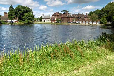
Lullingstone Country Park in Kent offers a circular walk across an undulating landscape. The route offers a view of Lullingstone Castle, which is only open on special occasions, the nearby lake, attractive parkland, the remains of a Roman villa, woodland and many other points of interest around the walk. The circular walk follows a waymarked path with black arrows. A longer similar version of this route can be found at Walk 2156.
The start is the Lullingstone Country car park (grid ref. TQ526638) which lies a short distance off the A225 near Eynsford. After parking locate the riverside path and turn north (left). You follow a short section of the Derwent Valley path passing the lake on your right. At the end of the lake the route joins a tarmac drive. Continue past the impressive brick gatehouse through which you can see Lullingstone Castle. Continue ahead along the drive for a further 600 metres to reach the Lullingstone Roam Villa which is manged by English Heritage (fee payable).
Just before reaching the Roman villa, turn left along a wide gravel path (grid ref. TQ530651) into woodland (marker post with black arrow). The grassy track continues ahead for 900 metres following the black arrow waymarks. The path then turns left (grid ref. TQ522654). Continue along the clear path past Parkgate Farm on your right to reach Lullingstone Park Golf Course. Car park (grid ref. TQ507645). Continue through the car park and take the paved path to the right of the club house and golf course. After 150 metres bear right at a fingerpost (signed Circular Walk) and continue through Beechen Wood back to the start follow the waymarks with black arrows.
Other walks nearby
| Walk 1510 | Otford, Romney Street & Woodlands | moderate | 14.5 miles |
| Walk 1610 | Otford, Romney Street & Kemsing | mod/hard | 16.8 miles |
| Walk 3598 | Knockholt via Pratt's Bottom, Mace Farm and The Washneys | easy/mod | 7.3 miles |
| Walk 3441 | Sevenoaks, Seal Chart and Ightham Mote | moderate | 11.0 miles |
| Walk 2210 | Holly Hill & Coldrum Long Barrow | easy/mod | 5.0 miles |
| Walk 2011 | Chartwell from Crockham Hill | easy | 2.8 miles |
| Walk 2284 | Limpsfield Circular | easy/mod | 6.0 miles |
| Walk 2427 | Hever & Markbeech from Chiddingstone | easy | 5.9 miles |
| Walk 1398 | Greenwich Museum, Observatory & Park | easy | 2.3 miles |
| Walk 1471 | Thames Path - Cutty Sark to Tower of London | easy | 6.0 miles |
Recommended Books & eBooks
Walking in Kent
 A guidebook describing 40 walks in the county of Kent. Covering west Kent and The Weald and north and east Kent, including the Kent Downs and the Greensand Hills. Walks of 5 to 9 miles explore rivers and coastline, beautiful countryside and historic villages. With outlines of 11 longer walks ranging from 15 to 163 miles.
More information
Messaging & Social Media
Message Walking Britain and follow the latest news.

Mountain Weather
Stay safe on the mountains with detailed weather forecasts - for iOS devices or for Android devices.