Mynydd y Llan & source of the Usk
Brecon Beacons/Bannau Brycheiniog Walk
Nat Park - Brecon Beacons - Brecon Beacons West
County/Area - Carmarthenshire
Author - Lou Johnson
Length - 6.7 miles / 10.9 km Ascent - 800 feet / 242 metres
Time - 4 hours 10 minutes Grade - easy/mod
Maps 

| Ordnance Survey Explorer OL12 | Sheet Map | 1:25k | BUY |
| Anquet OS Explorer OL12 | Digital Map | 1:25k | BUY |
Walk Route Description
Click image to see photo description.
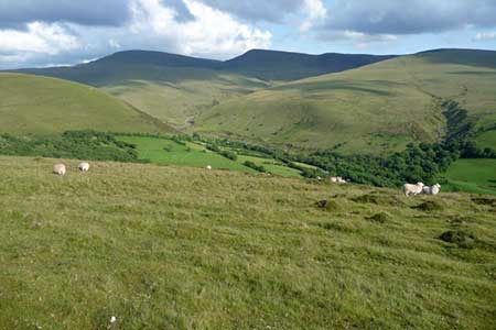
This circular walk in the Brecon Beacons National Park covers an area of wild moorland north of Llanddeusant. The route starts from Pont'ar Wysg and crosses the moor before descending into a valley of fertile farmland. The walk continues to cross the flank of Mynydd y Llan (423 m) with views south to the Black Mountains including the summit of Picws Du. Veering north the route crosses moorland which is the source of the River Usk to return to the start. The relevant Ordnance Survey 1:25k map is useful for the final section of the walk.
The route starts from the car park on the Powys side of Pont'ar Wysg (grid ref. SN820271). After parking cross the bridge into Carmarthenshire and follow the lane across the moor. Continue for three kilometres to cross a cattlegrid. Continue for a further 400 metres and turn left down a track with adjacent fingerpost (grid ref. SN 787263). Continue down past Blaenllechach Farm (on your right) to a footbridge over the Afon LLechach. A clear track crosses a field with hedge on your right to reach some derelict building where you turn right to follow the continuing track. Stay on the track for 800 metres to reach a stream with woodland on your left and a footpath sign (grid ref. SN784252).
Turn left uphill and continue to reach open access land (grid ref. SN786252). Careful navigation is required from this point. Continue ahead uphill onto Mynydd y Llan. As you make progress up the slope there are excellent views across wild country to the imposing Carmarthen Fans including Picws Du and the steep escarpment. The path keeps the summit of Mynydd y Llan on your left and maintains direction roughly to the east. Two kilometres from entering the moor, the path approaches the steep sided valley containing Nant y Cregiau. Reaching a path junction (grid ref. SN804247, continue ahead with Bryn Mawr rising to your left.
Continue up and across a shallow col and start to descend. There is no clear path across the open moorland. Initially the route heads northeast and after 600 metres veer half left and walk parallel to the infant River Usk which is on your right. In clear weather the route back to the start fords two side streams before reaching Pont'ar Wysg. Turn right across the bridge and return to the car park.
Other walks nearby
| Walk 3559 | Picws Du & Llyn y Fan Fach from near Llanddeusant | moderate | 5.3 miles |
| Walk 1672 | Llyn-y-Fan-Fawr & Mynydd Ddu from Llanddeusant | mod/hard | 12.0 miles |
| Walk 3555 | Carreg yr Ogof & Bannau Sir Gaer from Llanddeusant | moderate | 6.7 miles |
| Walk 3563 | Fan Brycheiniog and Picws Du | moderate | 7.1 miles |
| Walk 2645 | Fan Gyhirych & Fan Bwlch Chwyth, Fforest Fawr | moderate | 8.0 miles |
| Walk 2646 | Fan Nedd & Fan Bwlch Chwyth, Fforest Fawr | moderate | 7.0 miles |
| Walk 2647 | Fan Gyhirych, Fan Nedd & Fan Bwlch Chwyth | moderate | 10.0 miles |
| Walk 2643 | Fan Frynych & Fan Llia, Fforest Fawr | moderate | 8.0 miles |
| Walk 2641 | Fan Fawr & Fan Frynych, Fforest Fawr | moderate | 6.5 miles |
| Walk 2648 | The Black Mountain, Brecon Beacons | moderate | 8.0 miles |
Recommended Books & eBooks
Walking on the Brecon Beacons
 45 circular day walks are described in this guidebook to the Brecon Beacons National Park. From west to east, Mynydd Du, Fforest Fawr, the Brecon Beacons and the Black Mountains these mountain and valley routes offer many options, highlighting the natural features. The walks described explore dramatic waterfalls, wooded gorges and upland valleys.
More information
Walking in Carmarthenshire
 Guidebook to 30 walking routes (2 to 10 miles) in Carmarthenshire, south Wales, including sections of Carmarthenshire Coast Path. Walks for all abilities, including coastal, river, forest and hill walks in Cambrian Mountains, Tywi Valley, Y Mynydd Du (Black Mountains) and Brecon Beacons. Easy access from Bristol, Cardiff and Swansea.
More information
Messaging & Social Media
Message Walking Britain and follow the latest news.

Mountain Weather
Stay safe on the mountains with detailed weather forecasts - for iOS devices or for Android devices.