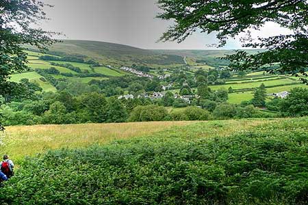
Withypool & Barle Valley from Landacre Bridge
Pub Walk + Riverside Walk
Nat Park - Exmoor
County/Area - Somerset
Author - Lou Johnson
Length - 6.0 miles / 9.8 km Ascent - 950 feet / 288 metres
Time - 4 hours 0 minutes Grade - easy/mod
Maps 

Walk Route Description
Click image to see photo description.
A circular walk exploring the Barle Valley near Withypool in the Exmoor National Park. The route follows a section of the Two Moors Way, passes the attractive village of Withypool which offers refreshments half-way through the walk. The return leg of the walk follows the River Barle through glorious countryside and after crossing moorland finishes at Landacre Bridge.
The walk starts from the small parking are on the south side of Landacre Bridge (grid ref. SS815361). After parking descend to the bridge and cross the River Barle. Cross the bridge and continue up the lane climbing quite steeply up past Landacre Farm. Another section of uphill walking leads to a cross track (grid ref. SS824367). Turn right along the restricted byway/bridleway signed to Withypool. You are now following a section of the Two Moors Way with open moorland to your left. The track soon reaches a gate and continues a gradually descends towards Withypool with views of the Barle Valley on your right.
After a mile of easy walking, you reach a tarmac drive on the right with a stile and adjacent fingerpost (grid ref. SS841360). After crossing the stile the path enters a field and then continues downhill, waymarked with yellow arrows, to reach the village of Withypool. After heavy rain or when the river is running high ignore the next section of the route and turn right through the village and cross the river.
Turn left through the village, pass the Royal Oak, and continue ahead to exit the village. The road starts to climb. Take the next signed footpath on the right signed to Tarr Steps (grid ref. SS8503560. The onward path, still part of the Two Moors Way. The route is signed and descends to the River Barle. Cross the stepping stones with care and pick up the rising path on the far side of the river. Follow the path uphill passing to the left of the buildings at South Hill. The path then joins the properties access drive and continues to Worth Lane. Turn right and follow the lane down to the river in Withypool.
Just before the bridge turn left onto a footpath signed to Landacre Bridge (or if omitting the stepping stones loop, turn right onto the signed path). Initially the path keeps close company with the river. The route is signed Landacre Bridge and eventually veers left up to Brightworthy Farm. The path goes around the back of the farm and the onward path is signed. Cross a stile and turn right along a green lane. Reaching open moorland continue ahead to a lane. Turn right and the car park is a short way downhill on the right.
Other walks nearby
| Walk 3386 | Barle Valley & Cow Castle from Simonsbath | easy/mod | 6.4 miles |
| Walk 1860 | The River Barle and Withypool from Tarr Steps | easy/mod | 7.5 miles |
| Walk 1669 | Anstey Gate & Hawkridge from Tarr Steps | moderate | 8.2 miles |
| Walk 2154 | West Anstey Common from Molland | easy/mod | 6.4 miles |
| Walk 1222 | Winsford Hill & the Allotment | moderate | 6.0 miles |
| Walk 1750 | Dunkery Beacon (short ascent) | easy/mod | 2.5 miles |
| Walk 1727 | Shallowford, Hoar Oak Tree & The Chains | moderate | 11.7 miles |
| Walk 2387 | Pinkery Pond Circular | easy/mod | 5.8 miles |
| Walk 1220 | Dunkery Beacon | moderate | 8.0 miles |
| Walk 1263 | The Doone Valley | moderate | 8.5 miles |
Recommended Books & eBooks
No suggestions for this area.Messaging & Social Media
Message Walking Britain and follow the latest news.

Mountain Weather
Stay safe on the mountains with detailed weather forecasts - for iOS devices or for Android devices.