Plumpton Green & South Downs
Pub Walk + Hill Walk + Countryside
Nat Park - South Downs
County/Area - East Sussex
Author - Lou Johnson
Length - 7.7 miles / 12.5 km Ascent - 800 feet / 242 metres
Time - 4 hours 40 minutes Grade - easy/mod
Maps 

| Ordnance Survey Explorer OL11 | Sheet Map | 1:25k | BUY |
| Anquet OS Explorer OL11 | Digital Map | 1:25k | BUY |
Walk Route Description
Click image to see photo description.
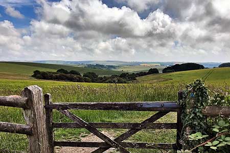
Walk from Plumpton station exploring countryside and downs. Trains from London Victoria take just over an hour. The route follows paths, including a section of the South Downs Way, across agricultural land before climbing the north-facing escarpment of the South Downs from where there are glorious views. The return route descends from the downs and passes the Grade II listed church at Chiltington. Refreshments are available at the Half Moon Inn at Plumpton at the half-way point of the walk.
The walk starts from Plumpton railway Station (grid ref. TQ364161). Exit the station at the northwestern end of the platforms and turn left to Plumpton Racecourse. Continue past the course (on your left), grandstand and other buildings along a concrete road to reach a T-junction (grid ref. TQ362153). Turn left and after 100 metres turn left along a track which leads pass farm buildings on your right to become a footpath heading south across open countryside. After 1.6 kilometres you reach the Agricultural College. Continue ahead and 140 metres beyond the last building turn left through gates. Continue half-right across the field to exit through trees onto the B2116 (grid ref. TQ363132).
Turn left past the Half Moon Inn and turn right at the next junction along a track (Plumpton Bostall). The track climbs steeply across the face of the escarpment to reach the South Downs Way (grid ref. TQ356127) with views improving as height is gained. Turn left and continue for 1.5 kilometres enjoying views left and right to pass through a gate (grid ref. TQ370125). Turn left leaving the South Downs Way and descend a bridleway. The clear track leads downhill and after 800 metres reaches a cross path (grid ref. TQ376128) marked by an arrow. The bridleway loops down the face of the escarpment and leads to the B2116.
Cross the road with care and join the signed bridleway which heads north across farmland. After passing Warninggore Farm on your left, keep ahead on a clear track which soon becomes fringed by trees. When the track turns right, bear left (yellow waymark) following a path along the right-hand side of fields to reach a lane by Wootton Farm (grid ref. TQ380151). Keep the farm buildings on your right and follow an access drive to Novington Lane. Cross the stile by a post box into a field. Head straight across three fields to reach a lane in Chiltington (grid ref. TQ370151).
Turn left with East Chiltington church ahead. Built in the 12th and 14th centuries, the church is a listed building and worth a visit. To continue this walk take the track turning right alongside the churchyard wall. This bridleway heads west partially through trees to reach Plumpton Lane (grid ref. TQ364153). Turn right and almost immediately left along the access road to Plumpton Racecourse. Retrace your route past the buildings and grandstand and return to Plumpton railway station.
Other walks nearby
| Walk 2684 | Falmer to Pyecombe & Blackcap by South Downs Way | moderate | 8.8 miles |
| Walk 2903 | Stanmer to Streat | moderate | 12.5 miles |
| Walk 3213 | Pyecombe, Devil's Dyke & Upper Beeding | easy/mod | 8.0 miles |
| Walk 2236 | Wolstonbury Hill and Pyecombe from Patcham | moderate | 11.0 miles |
| Walk 3487 | Edburton Hill & Devil's Dyke from Saddlescombe | hard | 10.5 miles |
| Walk 1770 | Southease or Rodmell to Falmer | easy/mod | 6.8 miles |
| Walk 3488 | Devil's Dyke Circular | easy | 2.5 miles |
| Walk 2419 | Southease, Ditchling Beacon & Lewes | mod/hard | 17.0 miles |
| Walk 1038 | Firle Beacon | moderate | 13.3 miles |
| Walk 1983 | Edburton Hill from Fulking | easy/mod | 6.1 miles |
Recommended Books & eBooks
Walks in the South Downs National Park
 Guidebook with 40 circular walks throughout the South Downs National Park, exploring the beautiful chalk hills between Eastbourne and Winchester. The walks range from under 5 miles to 11 miles, including Beachy Head and the Seven Sisters, Ditchling Beacon and hundreds of prehistoric sites. Accessible all year, but wild flowers best in spring.
More information
The South Downs Way
 Guidebook to walking the South Downs Way National Trail, a 100 mile (160km) route between Winchester and Eastbourne through the South Downs National Park, described in both directions over 12 stages. Easy walking on ancient and historical tracks, taking in wooded areas, delightful river valleys and pretty villages. With 1:25K OS map booklet.
More information
Messaging & Social Media
Message Walking Britain and follow the latest news.

Mountain Weather
Stay safe on the mountains with detailed weather forecasts - for iOS devices or for Android devices.