Huddersfield's green fringe
West Yorkshire Walk
County/Area - West Yorkshire - Kirklees
Author - Peter Schofield
Length - 10.0 miles / 16.3 km Ascent - 800 feet / 242 metres
Time - 5 hours 50 minutes Grade - easy/mod
Maps 

| Ordnance Survey Explorer 288 | Sheet Map | 1:25k | BUY |
| Anquet OS Explorer 288 | Digital Map | 1:25k | BUY |
| Ordnance Survey Landranger 110 | Sheet Map | 1:50k | BUY |
| Anquet OS Landranger 110 | Digital Map | 1:50k | BUY |
Walk Route Description
Click image to visit gallery of 6 images.
This walk is along well established paths to the south west of Huddersfield. Although some of it is close to an urban area, it retains a remarkably rural feel throughout and being close to the town it's well served by public transport.
The walk starts at the crossroads in the centre of the large village of Meltham (GR 099106) approximately five miles south west of Huddersfield and on the fringe of the Peak District National Park. From the start point go north down Station St for approximately 200m and then right on to a path into a supermarket car park. Continue to the right of the supermarket as the route passes a small housing development to become a broad tarmac path. This is the Meltham Greenway, a former railway which after closure was used by the nearby David Brown Tractor Company as a test track. Several information boards on the path tell of this phase of its existence.
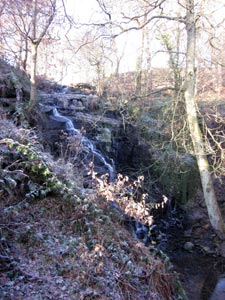
After a further 400m, go left through a metal gate on to a permissive footpath paralleling a stream to your right. To the right is local beauty spot Folly Dolly Falls which are particularly impressive after heavy rain and a viewing area is accessible from the path. Where the permissive path ends at a stile, go right over a couple of stiles and climb the waymarked path to the left of a house above. Going around the top side of the house, climb a grassy bank opposite its entrance to reach a tarmac lane (GR 107116).
Turn left and after 100m go right up a waymarked path over a stile and cross a field by a clear path as views open out, particularly behind you towards West Nab and the national park. Arriving at the walled track of Far Fields Lane go right and after 200m right again through a narrow field gate to descend through a couple of fields to a four way path junction at the edge of a wood (GR 111122). To the right, a local folly the Jubilee Tower is prominent on the skyline.
At the path junction, keep to the left hand path which follows a wall at the top of the wood to reach a stile after 300m. Cross over and climb up to Far Fields Lane, turning right and then immediately left along another bridleway. After 200m go right on to a path to reach a quiet road at the north end of the village of South Crosland. Turn left and fork immediately right down a lane as it descends towards Dean Clough where after 70m, a waymarked path to the right leads into the attractive woodland of Dean Wood.
A clear path leads through the wood becoming a road which leads into the centre of Netherton village. Cross the main road and go straight on along Moor Lane for 30m then right into Netherton Fold. After 100m, bear left on to Corn Bank where several period buildings from the original settlement can be seen. The tarmac becomes a path which goes along the top side of a wooded valley as views open up the valley towards Meltham and the hills of the national park. and then descends gently to arrive at a kissing gate at a road corner.
Continue ahead down the road for 200m before turning left into another road where after 200m, a bridleway bears to the right. Follow the bridleway as it descends through Mag Wood above the River Holme to arrive at a lane in the hamlet of Armitage Bridge. In front is the historic Brooke's textile mill, parts of which date back to the 17thC and which is now finding new life as a centre for small creative businesses. Go right and then left on to Armitage Road before bearing right after 100m along a path behind a row of houses.
Where a road enters from the left by the oddly named "Monkey Club", continue ahead past the cricket club to reach the bank of the River Holme. The route follows the side of a fence to arrive at the entrance to a mill complex. Climb up the access road where to the right there's a fine view of the graceful arches of Lockwood Viaduct built in the 1840s for the Huddersfield to Penistone railway and still in use today. After 50m you arrive at the main road between Huddersfield and Meltham (GR 129145) where if you wish to terminate the walk, a frequent bus service runs back to the start.
To continue, go over the road and continue up a path which climbs to reach the trackbed of the former Meltham branch line. Cross the old railway and climb the steps which lead into the classic Victorian municipal parkland of Beaumont Park opened in 1883 as Huddersfield's first public park and recently restored to its former glory. Turn left at the top of the climb and follow the broad tarmac park path past the visitor centre to the west entrance at Butternab Road (GR 125138). Turn right and after 50m go left along a waymarked woodland path which arrives at a lane after 600m.
Cross the lane and bear right along a bridleway, keeping left as it first crosses a lane and then passes the hangar of Huddersfield airfield. After 1.2K, turn left at Hadden Farm and drop down to a tarmac lane. Go right along the lane for 1K as it first rises and then descends giving views over Blackmoorfoot reservoir towards the hills above Marsden & Meltham. Turn left on to the reservoir access road (GR 101131) and after 100m, turn right through a gate on to the reservoir circuit path. Follow the path along the eastern and southern sides to a feeder conduit (GR098123) where you take the path on the left of the conduit to a stile at a bridge. Crossing the stile, go immediately left through a narrow entrance and on to the in parts muddy path as it descends to the pretty hamlet of Helme.
Passing a kissing gate, cross the road and continue straight on past the church. Some 50m beyond, fork right on a tarmac path which descends to Helme Lane. Go right and after 100m, turn left through a gate to follow a clear path descending across Meltham recreation ground to Broadlands Road. bear left, after 200m go right to the junction with Station St and then turn left from where the starting point is 300m up the hill.
This walk is easily accessible by public transport as buses 321 and 324 operate a very frequent weekday service between Huddersfield, Netherton and Meltham (every 30 mins on Sunday). Full timetable information can be found at www.wymetro.com.
Other walks nearby
| Walk 1586 | Blackmoorfoot Reservoir | easy | 1.5 miles |
| Walk 2561 | Digley & Ramsden Reservoirs from Wessenden Head | moderate | 9.5 miles |
| Walk 1583 | Digley Reservoir | easy/mod | 5.0 miles |
| Walk 2518 | Black Hill & Four Reservoirs from near Wessenden Head | moderate | 10.0 miles |
| Walk 2630 | Upper Holme Valley & Ramsden Clough | moderate | 9.0 miles |
| Walk 2613 | Boundary Walk from Marsden | moderate | 13.0 miles |
| Walk 1829 | Holme & Marsden Clough from Ramsden Reservoir | moderate | 9.0 miles |
| Walk 2359 | Cuckoo Walk & Bacon Butties from Marsden | hard | 19.5 miles |
| Walk 2644 | Marsden and the Standedge Trail | moderate | 11.0 miles |
| Walk 2926 | Cupwith & Shooter's Nab from Marsden | moderate | 13.0 miles |
Recommended Books & eBooks
No suggestions for this area.Messaging & Social Media
Message Walking Britain and follow the latest news.

Mountain Weather
Stay safe on the mountains with detailed weather forecasts - for iOS devices or for Android devices.