The High Peaks of the Brecon Beacons
Brecon Beacons/Bannau Brycheiniog Walk
Nat Park - Brecon Beacons - Brecon Beacons Central
County/Area - Powys
Author - Lou Johnson
Length - 10.7 miles / 17.4 km Ascent - 2800 feet / 848 metres
Time - 8 hours 10 minutes Grade - mod/hard
Maps 

| Ordnance Survey Explorer OL12 | Sheet Map | 1:25k | BUY |
| Anquet OS Explorer OL12 | Digital Map | 1:25k | BUY |
Walk Route Description
Click image to see photo description.
This walk offers an in-depth look at the highest land in the Brecon Beacons visiting the summits of Corn Du, Pen y Fan, Cribyn and Fan y Big. The route offers some spectacular views, excellent walking and follows a section of the Beacons Way long-distance path. To reach the start from the main A465 (Heads of the Valleys road) at Merthyr Tydfil, take the road on the west side of the Pontsticill Reservoir into the Taf Fechan Forest. Turning off towards the Upper Neuadd Reservoir there is a car park at grid ref. SO035173 where there is usually ample space.
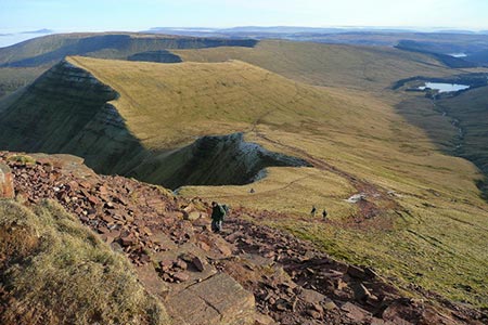
After parking, walk north up the lane to the Filter House and across the abandoned dam wall. Enter Open Country and follow the steep path on the north side of the plantation. The climb is soon over and you reach the north of the 642m. trig point. Turn right (north) along the edge where you can make fast progress while enjoying view which includes the Upper Neuadd Reservoir and the summits that are your main objective.
The edge walk is superb with the red sandstone of the rocky outcrops adding colour to the scene especially in sunshine. After walking along the top of the cliffs of Graig Fan Ddu you reach a lovely section where the ridge narrows offering views west into Nant Crew. Corn Du is the first summit to be gained and is an easy walk rewarded by an excellent panorama particularly north to Brecon and the rolling hills of Central Wales. The summit of Corn Du also offers the first chance during the walk to see the steep north facing escarpment. Falling over one thousand feet to the u-shaped valleys below, these cliffs are partly grassed. Also of note are the ridges heading north which offer alternative ways onto the summits.
A short walk away is Pen y Fan (2906 ft./ 886 m.) the highest point in South Wales and the Brecon Beacons National Park. Again, the summit provides an excellent viewpoint east along the escarpment to Cribyn, Fan y Big and beyond. The proximity of Storey Arms makes Pen y Fan a popular short walk so do not expect to enjoy the views in solitude. As can be seen the onward route involves steep ascents and descents. These can be tedious as there is little of interest underfoot.
From Pen y Fan follow the escarpment edge to Cribyn where a good view back to Pen y Fan can be enjoyed. Another descent takes you down to Bwlch ar y Fan. If the weather worsens or if you have run out of energy then turn south from Bwlch ar y Fan and follow the easy graded path south to the starting point of the walk. However, this walk continues over Fan y Big, the next summit along the escarpment, which involves 400 feet of ascent, which is the last major climb of the walk.
Leave Fan y Big, heading south along the escarpment edge following the Beacons Way long-distance path, which has been followed for part of the route from Pen y Fan. After 800 metres along the edge, a path joins the edge path from the right (grid ref. SO038197). The path gradually swings to the left and heads east. 400 metres after the previous path junction, turn right onto a less distinct path at grid ref. SO041196). Reference to a 1:25000 OS map helps in identifying this path which is the continuation of the Beacons Way. The path initially heads south but then heads east to reach an easterly facing escarpment and a much clearer path (grid ref. SO050191).
Turn south along the edge following the Beacons Way over the eastern side of Craig y Fan Ddu. The route descends quite steeply to reach a corner of a large plantation (grid ref. SO054179). Continue down the path with the plantation to your left to reach the access track to a parking area on your left. Turn right down the car park access track and then walk right along the road. Stay on this road until you reach a junction with a small parking area after a kilometre. Turn right through the parking area and where the tracks fork bear right. After a mile, you reach the lane used for the outward route (grid ref. SO035173). Turn sharp left and the car park used at the start is a short way down this lane on your right.
Other walks nearby
| Walk 1552 | Waun Rydd | easy/mod | 5.5 miles |
| Walk 1283 | Fan y Big from Torpantau | moderate | 8.5 miles |
| Walk 2349 | Pen Y Fan & Corn Du from near Storey Arms | moderate | 4.6 miles |
| Walk 3616 | Fan Fawr from Storey Arms | moderate | 6.0 miles |
| Walk 2400 | Pen y Fan from Cwmgwdi near Brecon | moderate | 5.0 miles |
| Walk 1903 | Pen y Fan & Corn Du from Cwmgwdi | moderate | 7.5 miles |
| Walk 2074 | Highest Peaks of the Brecon Beacons | mod/hard | 11.0 miles |
| Walk 2641 | Fan Fawr & Fan Frynych, Fforest Fawr | moderate | 6.5 miles |
| Walk 2648 | The Black Mountain, Brecon Beacons | moderate | 8.0 miles |
| Walk 3546 | Pen y Bryn from Pencelli | moderate | 5.0 miles |
Recommended Books & eBooks
The Cambrian Way
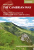 Guidebook to the Cambrian Way, a challenging three-week mountain trek through Wales from Cardiff to Conwy. The 470km un-waymarked route is presented from south to north. Often sticking to long, beautiful ridgelines, it crosses wild and rugged terrain and visits many of Wales's highest mountains, including Snowdon.
More information
Walking on the Brecon Beacons
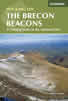 45 circular day walks are described in this guidebook to the Brecon Beacons National Park. From west to east, Mynydd Du, Fforest Fawr, the Brecon Beacons and the Black Mountains these mountain and valley routes offer many options, highlighting the natural features. The walks described explore dramatic waterfalls, wooded gorges and upland valleys.
More information
Messaging & Social Media
Message Walking Britain and follow the latest news.

Mountain Weather
Stay safe on the mountains with detailed weather forecasts - for iOS devices or for Android devices.