Walk 2148 - printer friendly version
Simonside Circular Walk
Author - Lou Johnson
Length - 4.7 miles / 7.6 km
Ascent - 800 feet / 242 metres
Grade - easy/mod
Start - OS grid reference NZ037997
Lat 55.2914050 + Long -1.9432838
Postcode NE65 7RR (approx. location only)
The Simonside hills rise above the Coquet Valley in the Northumberland National Park. The highest point is Simonside which lies at the western end of a ridge containing two other minor summits. The ridge offers excellent views across the Coquet Valley to the higher hills in the northern part of the National Park.
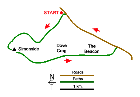
The start is the Simonside car park (grid ref. NZ037997) which lies just over a kilometre southeast of Great Tosson on the south side of a minor road. After parking, and with your back to the road, take the footpath at the left hand end of the car park between large stones set in the ground. The path follows a meandering route through the trees. Keep to the clearer path at the first junction. Continue ahead to reach a cross track and go straight across climbing gently with Coe Burn below to your left. Reaching a broad track, with a way post to the left of the path, turn left (grid ref. NZ033922).
Continue uphill with Coe Burn still on your left. Reaching a T-junction, with a good view ahead to Simonside and the ridge, turn right. Walk uphill for about a kilometre, passing a seat and information board on the right, to reach an information board on the left. Turn left up the stone steps for a steep ascent to the summit of Simonside with its large cairn. Take time to enjoy the panoramic view. Continue along the paved path to a unnamed rocky outcrop with a smaller cairn.
Follow the clear path (paved in places) along the continuing ridge passing over Old Stell Crag (no cairn) and then gently rising to reach Dove Crag (cairn above on the right). Continue along the clear path, pass through a gate and walk onto Dove Crag (cairn on right slightly above the path). Descend gently across the moor on a clear path. After 1.7 kilometres to reach a road with a car park opposite (grid ref. NZ052988). Turn left along the road and continue back to the car park which is reached after under two kilometres of easy walking. It is easy to walk past the car park entrance as there is no sign!
Messaging & Social Media
Message Walking Britain and follow the latest news.

Mountain Weather
Stay safe on the mountains with detailed weather forecasts - for iOS devices or for Android devices.