Simonside Circular
Northumberland Walk
Nat Park - Northumberland
County/Area - Northumberland County
Author - Lou Johnson
Length - 4.7 miles / 7.6 km Ascent - 800 feet / 242 metres
Time - 3 hours 10 minutes Grade - easy/mod
Maps 

| Ordnance Survey Explorer OL42 | Sheet Map | 1:25k | BUY |
| Anquet OS Explorer OL42 | Digital Map | 1:25k | BUY |
Walk Route Description
Click image to see photo description.
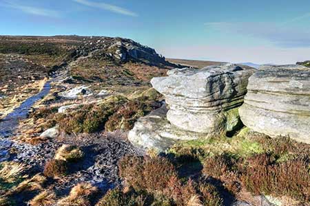
The Simonside hills rise above the Coquet Valley in the Northumberland National Park. The highest point is Simonside which lies at the western end of a ridge containing two other minor summits. The ridge offers excellent views across the Coquet Valley to the higher hills in the northern part of the National Park.
The start is the Simonside car park (grid ref. NZ037997) which lies just over a kilometre southeast of Great Tosson on the south side of a minor road. After parking, and with your back to the road, take the footpath at the left hand end of the car park between large stones set in the ground. The path follows a meandering route through the trees. Keep to the clearer path at the first junction. Continue ahead to reach a cross track and go straight across climbing gently with Coe Burn below to your left. Reaching a broad track, with a way post to the left of the path, turn left (grid ref. NZ033922).
Continue uphill with Coe Burn still on your left. Reaching a T-junction, with a good view ahead to Simonside and the ridge, turn right. Walk uphill for about a kilometre, passing a seat and information board on the right, to reach an information board on the left. Turn left up the stone steps for a steep ascent to the summit of Simonside with its large cairn. Take time to enjoy the panoramic view. Continue along the paved path to a unnamed rocky outcrop with a smaller cairn.
Follow the clear path (paved in places) along the continuing ridge passing over Old Stell Crag (no cairn) and then gently rising to reach Dove Crag (cairn above on the right). Continue along the clear path, pass through a gate and walk onto Dove Crag (cairn on right slightly above the path). Descend gently across the moor on a clear path. After 1.7 kilometres to reach a road with a car park opposite (grid ref. NZ052988). Turn left along the road and continue back to the car park which is reached after under two kilometres of easy walking. It is easy to walk past the car park entrance as there is no sign!
Other walks nearby
| Walk 1202 | The Simonside Hills near Rothbury | easy | 4.5 miles |
| Walk 2095 | Simonside Hills & Rothbury | moderate | 7.9 miles |
| Walk 2163 | Darden Pike & Darden Lough | easy/mod | 4.2 miles |
| Walk 3085 | The Dodd & Wether Cairn | moderate | 9.5 miles |
| Walk 1805 | An introduction to the Breamish Valley | easy | 2.0 miles |
| Walk 1766 | Cushat Law and Bloodybush Edge from Hartside | mod/hard | 12.5 miles |
| Walk 2282 | Bewick Moor | moderate | 9.1 miles |
| Walk 1200 | Windy Gyle | moderate | 7.5 miles |
| Walk 1763 | Mozie Law & Windy Gyle | moderate | 8.2 miles |
| Walk 2169 | Chew Green & Upper Coquet Valley | easy/mod | 5.8 miles |
Recommended Books & eBooks
Hadrian's Wall Path
 Hadrians Wall Path guidebook to walk the 84 mile National Trail. Described in both directions, the main description is west to east between Bowness-on-Solway and Wallsend, Newcastle, with extensions to Maryport and South Shields. With extensive historical information related to this World Heritage site and separate 1:25,000 OS map booklet included.
More information
Walking in Northumberland
 This guidebook contains detailed route descriptions for 36 day walks in Northumberland including the Cheviot Hills. The terrain varies from wild walks and craggy ascents to gentle riverside strolls. Each route ranges from 4 to 16 miles in length and there is the opportunity to link several walks together to create longer treks.
More information
Messaging & Social Media
Message Walking Britain and follow the latest news.

Mountain Weather
Stay safe on the mountains with detailed weather forecasts - for iOS devices or for Android devices.