Chew Green & Upper Coquet Valley
Northumberland Walk
Nat Park - Northumberland
County/Area - Northumberland County
Author - Lou Johnson
Length - 5.8 miles / 9.4 km Ascent - 800 feet / 242 metres
Time - 3 hours 40 minutes Grade - easy/mod
Maps 

| Ordnance Survey Explorer OL16 | Sheet Map | 1:25k | BUY |
| Anquet OS Explorer OL16 | Digital Map | 1:25k | BUY |
Walk Route Description
Click image to see photo description.
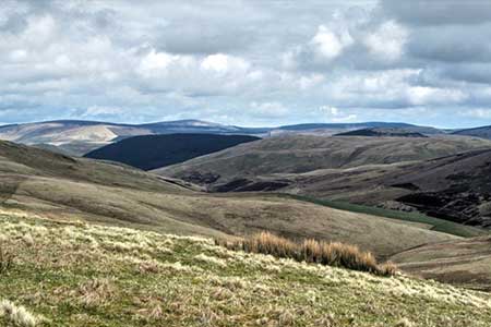
This walk in the Northumberland National Park explores an area of wild, hilly moorland close to the England Scotland border. The route visits the remains of the extensive Roman Fort at Chew Green and briefly follows a section of Dere Steet, a Roman road that connected York with Scotland. The walk passes near to the Otterburn firing range and you should check on the internet if any restrictions are in place on the day you visit.
The start is the small parking area at Buckham's Bridge (grid ref. NT824107). To reach this lonely spot, drive to the small community of Alwinton, west of Rothbury, and follow the no through road up the Coquet Valley for 10 miles to reach the parking area. The drive up the valley provides a useful introduction this remote and sparsely populated area.
After parking follow the road up the valley in company with the upper reaches of the River Coquet. The first landmark is the farm at Fulhope. Which is followed by a short climb after which the gradient eases. The final sign of habitation is Makendon Farm. The adjacent sheep pens suggest the reason why the farm occupies such a lonely place. Topping a rise a short descent leads to the car park at Chew Green (NT794086).
Continue a short way along the road and veer right through a gateway to join the Pennine Way at a four-way fingerpost (grid ref. NT792084). Turn right along the Pennine Way which follows Dere Street at this point. As you start a steady climb the remains of the Roman Fort can be seen on your left. Reaching a marker post, turn right and cross a footbridge. Reaching a three-way fingerpost ignore the path on the right to Makendon and continue on the Pennine Way. Pass through the next gate and continue to another gate just short of the border fence (grid ref. NT791096). Pass through this gate and then head half-right, leaving the Pennine Way, across the moor.
If the visibility is poor return to the road and follow the outward route as there are few landmarks on onward route. Using the fence on your right as a guide, continue slightly downhill to reach The Dodd. Maintain direction towards Deel's Hill ahead from where a grassy track provides a descent down the hill's eastern ridge to return to the car park at Buckham's Bridge. This section offers a fine view into Upper Coquetdale and to the surrounding hills.
Other walks nearby
| Walk 1200 | Windy Gyle | moderate | 7.5 miles |
| Walk 1763 | Mozie Law & Windy Gyle | moderate | 8.2 miles |
| Walk 3353 | The Roman Camp at Chew Green | easy/mod | 5.8 miles |
| Walk 3085 | The Dodd & Wether Cairn | moderate | 9.5 miles |
| Walk 2299 | The Cheviot | moderate | 9.0 miles |
| Walk 3296 | Grubbit Law & Hownam Law from Morebattle | moderate | 7.0 miles |
| Walk 1766 | Cushat Law and Bloodybush Edge from Hartside | mod/hard | 12.5 miles |
| Walk 1764 | The Cheviot from Langleeford | mod/hard | 8.2 miles |
| Walk 1765 | Comb Fell & Hedgehope Hill from Langleeford | mod/hard | 8.9 miles |
| Walk 1776 | The Cheviot & Auchope Cairn from Langleeford | mod/hard | 10.0 miles |
Recommended Books & eBooks
The Pennine Way
 Guidebook to the Pennine Way National Trail with OS map booklet. The 265 mile route from Edale to Kirk Yetholm takes three weeks to walk and is suitable for fit and experienced long distance walkers. The route crosses the Peak District, Yorkshire Dales and North Pennines National Parks. Includes separate OS 1:25,000 map booklet of the route.
More information
Walking in Northumberland
 This guidebook contains detailed route descriptions for 36 day walks in Northumberland including the Cheviot Hills. The terrain varies from wild walks and craggy ascents to gentle riverside strolls. Each route ranges from 4 to 16 miles in length and there is the opportunity to link several walks together to create longer treks.
More information
Messaging & Social Media
Message Walking Britain and follow the latest news.

Mountain Weather
Stay safe on the mountains with detailed weather forecasts - for iOS devices or for Android devices.