Walk 2169 - printer friendly version
Chew Green & Upper Coquet Valley Walk
Author - Lou Johnson
Length - 5.8 miles / 9.4 km
Ascent - 800 feet / 242 metres
Grade - easy/mod
Start - OS grid reference NT824107
Lat 55.3899400 + Long -2.2793789
Postcode NE65 7BX (approx. location only)
This walk in the Northumberland National Park explores an area of wild, hilly moorland close to the England Scotland border. The route visits the remains of the extensive Roman Fort at Chew Green and briefly follows a section of Dere Steet, a Roman road that connected York with Scotland. The walk passes near to the Otterburn firing range and you should check on the internet if any restrictions are in place on the day you visit.
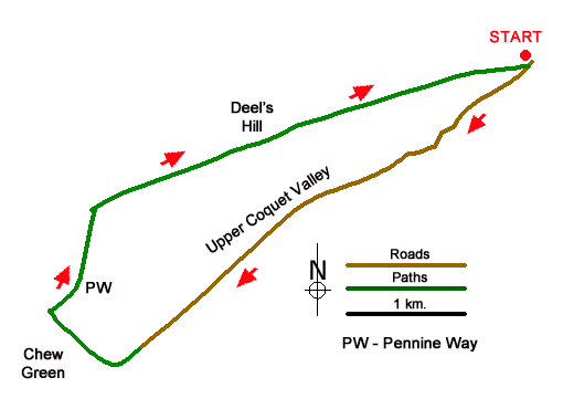
The start is the small parking area at Buckham's Bridge (grid ref. NT824107). To reach this lonely spot, drive to the small community of Alwinton, west of Rothbury, and follow the no through road up the Coquet Valley for 10 miles to reach the parking area. The drive up the valley provides a useful introduction this remote and sparsely populated area.
After parking follow the road up the valley in company with the upper reaches of the River Coquet. The first landmark is the farm at Fulhope. Which is followed by a short climb after which the gradient eases. The final sign of habitation is Makendon Farm. The adjacent sheep pens suggest the reason why the farm occupies such a lonely place. Topping a rise a short descent leads to the car park at Chew Green (NT794086).
Continue a short way along the road and veer right through a gateway to join the Pennine Way at a four-way fingerpost (grid ref. NT792084). Turn right along the Pennine Way which follows Dere Street at this point. As you start a steady climb the remains of the Roman Fort can be seen on your left. Reaching a marker post, turn right and cross a footbridge. Reaching a three-way fingerpost ignore the path on the right to Makendon and continue on the Pennine Way. Pass through the next gate and continue to another gate just short of the border fence (grid ref. NT791096). Pass through this gate and then head half-right, leaving the Pennine Way, across the moor.
If the visibility is poor return to the road and follow the outward route as there are few landmarks on onward route. Using the fence on your right as a guide, continue slightly downhill to reach The Dodd. Maintain direction towards Deel's Hill ahead from where a grassy track provides a descent down the hill's eastern ridge to return to the car park at Buckham's Bridge. This section offers a fine view into Upper Coquetdale and to the surrounding hills.
Messaging & Social Media
Message Walking Britain and follow the latest news.

Mountain Weather
Stay safe on the mountains with detailed weather forecasts - for iOS devices or for Android devices.