Penbryn & Llangrannog Circular
Ceredigion Walk
County/Area - Ceredigion
Author - Lou Johnson
Length - 5.4 miles / 8.8 km Ascent - 1100 feet / 333 metres
Time - 3 hours 50 minutes Grade - easy/mod
Maps 

| Ordnance Survey Explorer 198 | Sheet Map | 1:25k | BUY |
| Anquet OS Explorer 198 | Digital Map | 1:25k | BUY |
Walk Route Description
Click image to see photo description.
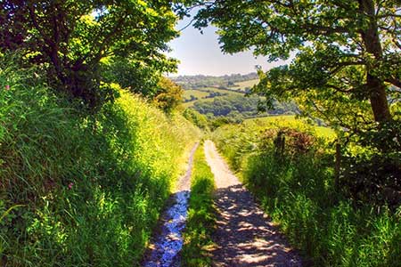
Starting from Penbryn this Ceredigion walk follows an inland route to Llangrannog from where the Wales Coast Path is used to return to the start. The inland section of the route follows paths and tracks across an undulating landscape. The coastal section rises to nearly 400 feet above sea level and offers fine views from the cliff tops.
The start is the Penbryn beach car park (grid ref. SN296521). After parking, walk towards the beach and turn right by a fingerpost up a track between hedges. After 250 metres the path splits. Turn right and pass to the left of Troedyrhiw. Just past the house, bear right and follow the path through woodland. Exiting the trees, turn left uphill and continue to a lane (grid ref. SN305521). Turn right down the lane and first left along a narrow lane. Continue up the lane for about 1.5 kilometres, ignoring the first track forking left, to the next gravel track on the left (grid ref. SN319523).
Turn sharp left up the track soon passing Locke's Cottage on your right. Follow the path up through trees to exit onto a track. Turn right and follow the track as it twists uphill. The clear track then continues between occasional trees to a lane. Turn right and continue for 400 metres and turn left along the access drive to Eisteddfa Farm. After passing the farm on your left and a large barn on your right, the track bends right. After a few metres turn left along a grassy track. After 160 metres, bear slightly right to join an enclosed path which descends into a wooded valley. Towards the end of the path, you have a view ahead to the sea. Pass a cottage on your right and follow the lane downhill. Keep left where the lane forks and continue down to the sea front in Llangrannog (grid ref. SN310542).
Turn left in front of the Pentre Arms and walk beside the beach. The lane climbs steeply, rounds a hairpin bend to reach a fingerpost. Leave the lane and join the Wales Coast Path, which is well waymarked. As with all coast paths, the route includes several climbs and descents. The initial climb takes you to Castell-bach, the site of a hillfort. The route then descends into a wooded valley before a final climb past a radio tower leads to the highest point of the coastal section from where the forward view south over Penbryn beach to the cliffs beyond is excellent. The path then descends towards Penbryn to reach the track used at the start of the walk. Turn right into Penbryn and return to the start.
Other walks nearby
| Walk 3493 | Llangrannog Circular | easy/mod | 4.5 miles |
| Walk 3492 | Trwyn Crou from Cwmtydu | moderate | 6.1 miles |
| Walk 2656 | New Quay to Cwmtydu using the coastal path | moderate | 8.0 miles |
| Walk 3429 | Byrlip and Ceredigion Coast Path from New Quay | easy/mod | 5.7 miles |
| Walk 3490 | Cemaes Head & Clawddcam from Poppit Sands | moderate | 8.3 miles |
| Walk 3491 | Cwm yr Esgyr & Cemaes Head from Poppit Sands | moderate | 6.1 miles |
| Walk 3494 | Pwllygranant & Cebwr Bay from Moylgrove | mod/hard | 8.5 miles |
| Walk 3468 | Foel Drygarn Hillfort, Preseli Hills | easy | 1.8 miles |
| Walk 3467 | Foel Drygarn Hillfort circular, Preseli Hills | easy/mod | 3.7 miles |
| Walk 2291 | Mynydd Carningli from Newport | easy/mod | 4.5 miles |
Recommended Books & eBooks
The Wales Coast Path
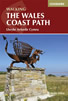 A single guidebook to walking the whole Wales Coast Path - 1400km (870 miles) the length of Wales from Chester to Chepstow, including Anglesey, described in 57 stages. The route passes through the Snowdonia and Pembrokeshire National Parks and many AONBs and can be linked with the Offa's Dyke Path for a complete circuit of Wales.
More information
Messaging & Social Media
Message Walking Britain and follow the latest news.

Mountain Weather
Stay safe on the mountains with detailed weather forecasts - for iOS devices or for Android devices.