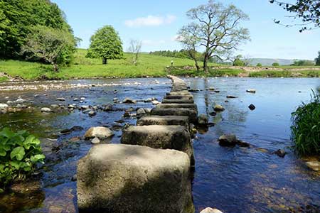
Hodder Valley from Whitewell
Forest of Bowland Walk
Region - Forest of Bowland
County/Area - Lancashire
Author - Lou Johnson
Length - 6.8 miles / 11.1 km Ascent - 700 feet / 212 metres
Time - 4 hours 10 minutes Grade - easy/mod
Maps 

| Ordnance Survey Explorer OL41 | Sheet Map | 1:25k | BUY |
| Anquet OS Explorer OL41 | Digital Map | 1:25k | BUY |
Walk Route Description
Click image to see photo description.
Starting from Whitewell this circular walk explores the Hodder Valley. The route follows the higher ground on either side of the river exploring the rolling farmland and countryside. The River Hodder is a tributary of the Ribble and meanders its way through the hills. Please note that after heavy rain the stepping stones may be impassable.
The start is the small parking area near St Michael's church (grid ref. SD659469) in Whitewell. After parking walk through the parking area down to the River Hodder and cross using the sturdy stepping stones. Once across the river, continue uphill with a wood on your left to the small community of New Laund. Walk towards the farm and turn left onto a footpath (grid ref. SD 655470). The onward path heads southwest for a kilometre to the extensive farm buildings at Fair Oak. Continue ahead into the farmyard and take the waymarked path to the right which leads beside barns and exits into a field. Aim to the left of a row of small trees on your right and exit via two stiles onto a road (grid ref. SD646459).
Turn right and then left along the access drive to Higher Greystoneley Farm. Walk between the buildings and join a grassy track heading south. Stay on the track heading south to Lower Greystoneley. Continue past buildings on your right and stay on the clear track. You soon pass Knot Barn on your right. Again, continue along the track which soon bears left and continues to a road (grid ref. SD640441). Turn right and then left by a fingerpost. Cross the cattle grid and continue along the driveway to Townley House. Waymarks show the route around the house with a left turn off the drive followed by a right turn and shortly after a left turn to join the path heading southeast with Townley Moss Wood on your right. Aim for the gap in a hedge and continue across the next field aiming for a group of trees. Cross the track and maintain direction across the next field to exit onto a road at a gate.
Walk ahead along the road to a T-junction. Turn left and cross Doeford Bridge. Taker the first signed path on the left. Cross the stile and head half-left and head up the field. Continue into the next field with the path running along the left-hand field edge. The path soon crosses to the other side of the hedge and continues with a hedge on your right to reach a track. Turn right and continue to where the track bends sharp right (grid ref. SD651437). At this point take the footpath on the left and continue across fields for a kilometre to a stile on Dunsford Road.
Turn left and then pass through the first gate on the right into a field. Turn sharp left,gate andough another gate, and walk to another gate in a wall. The onward path continues for a kilometre contouring around the side of Seed Hill to reach a pair of barns. Just past the barns join a clear track to a road (Hall Hill). Turn left into the centre of Whitewell and the start of the walk.
Other walks nearby
| Walk 2508 | Dunsop Fell & the Forest of Bowland | moderate | 10.0 miles |
| Walk 2510 | Totridge Fell via Langden & Bleadale Water | mod/hard | 10.0 miles |
| Walk 2555 | Whitendale from Dunsop Bridge | moderate | 8.0 miles |
| Walk 2556 | Whitendale & Dunsop Fell from Dunsop Bridge | mod/hard | 15.0 miles |
| Walk 2331 | Whin Fell & Ouster Rake from Dunsop Bridge | moderate | 8.3 miles |
| Walk 3505 | Whitewell via Crag Stones from Dunsop Bridge | easy/mod | 8.5 miles |
| Walk 2594 | Totridge Fell & Fiendsdale Head, Forest of Bowland | moderate | 11.0 miles |
| Walk 1218 | Fiensdale Head & Bleasdale Water | moderate | 10.0 miles |
| Walk 1902 | Saddle Fell, Fair Snape Fell & Parlick from Chipping | moderate | 8.0 miles |
| Walk 2505 | Fair Snape Fell from Fell Foot, Forest of Bowland | moderate | 6.0 miles |
Recommended Books & eBooks
Walking in the Forest of Bowland and Pendle
 A guidebook to 40 diverse circular day walks suitable for walkers with navigational skills. The Forest of Bowland and Pendle are two of north west England's upland AONBs, perfect for walkers who enjoy exploring rough hilly, sometimes pathless terrain. The routes include Ward's Stone, Pendle Hill, Longridge Fell and Fair Snape Fell.
More information
Walking on the West Pennine Moors
 This guidebook describes 30 walks on the West Pennine Moors, around Blackburn, Darwen, Chorley and Bolton, home to some of the most inspiring and exhilarating walking country. The walks range from short, easy rambles to more challenging hikes covering a variety of terrain, all of it easily accessible for day walking.
More information
Messaging & Social Media
Message Walking Britain and follow the latest news.

Mountain Weather
Stay safe on the mountains with detailed weather forecasts - for iOS devices or for Android devices.