Walk 2384 - printer friendly version
Hodder Valley from Whitewell Walk
Author - Lou Johnson
Length - 6.8 miles / 11.1 km
Ascent - 700 feet / 212 metres
Grade - easy/mod
Start - OS grid reference SD659469
Lat 53.9171130 + Long -2.5206594
Postcode BB7 3AT (approx. location only)
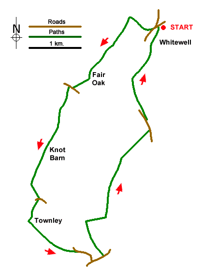
Starting from Whitewell this circular walk explores the Hodder Valley. The route follows the higher ground on either side of the river exploring the rolling farmland and countryside. The River Hodder is a tributary of the Ribble and meanders its way through the hills. Please note that after heavy rain the stepping stones may be impassable.
The start is the small parking area near St Michael's church (grid ref. SD659469) in Whitewell. After parking walk through the parking area down to the River Hodder and cross using the sturdy stepping stones. Once across the river, continue uphill with a wood on your left to the small community of New Laund. Walk towards the farm and turn left onto a footpath (grid ref. SD 655470). The onward path heads southwest for a kilometre to the extensive farm buildings at Fair Oak. Continue ahead into the farmyard and take the waymarked path to the right which leads beside barns and exits into a field. Aim to the left of a row of small trees on your right and exit via two stiles onto a road (grid ref. SD646459).
Turn right and then left along the access drive to Higher Greystoneley Farm. Walk between the buildings and join a grassy track heading south. Stay on the track heading south to Lower Greystoneley. Continue past buildings on your right and stay on the clear track. You soon pass Knot Barn on your right. Again, continue along the track which soon bears left and continues to a road (grid ref. SD640441). Turn right and then left by a fingerpost. Cross the cattle grid and continue along the driveway to Townley House. Waymarks show the route around the house with a left turn off the drive followed by a right turn and shortly after a left turn to join the path heading southeast with Townley Moss Wood on your right. Aim for the gap in a hedge and continue across the next field aiming for a group of trees. Cross the track and maintain direction across the next field to exit onto a road at a gate.
Walk ahead along the road to a T-junction. Turn left and cross Doeford Bridge. Taker the first signed path on the left. Cross the stile and head half-left and head up the field. Continue into the next field with the path running along the left-hand field edge. The path soon crosses to the other side of the hedge and continues with a hedge on your right to reach a track. Turn right and continue to where the track bends sharp right (grid ref. SD651437). At this point take the footpath on the left and continue across fields for a kilometre to a stile on Dunsford Road.
Turn left and then pass through the first gate on the right into a field. Turn sharp left,gate andough another gate, and walk to another gate in a wall. The onward path continues for a kilometre contouring around the side of Seed Hill to reach a pair of barns. Just past the barns join a clear track to a road (Hall Hill). Turn left into the centre of Whitewell and the start of the walk.
Messaging & Social Media
Message Walking Britain and follow the latest news.

Mountain Weather
Stay safe on the mountains with detailed weather forecasts - for iOS devices or for Android devices.