Mynydd Penarfynydd from Rhiw
Llyn Peninsula Walk
Region - Llyn Peninsula
County/Area - Gwynedd - Llyn Peninsula
Author - Lou Johnson
Length - 3.3 miles / 5.4 km Ascent - 600 feet / 182 metres
Time - 2 hours 20 minutes Grade - easy
Maps 

| Ordnance Survey Explorer 253 | Sheet Map | 1:25k | BUY |
| Anquet OS Explorer 253 | Digital Map | 1:25k | BUY |
Walk Route Description
Click image to see photo description.
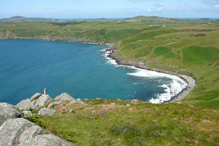
This walk from the hamlet of Rhiw in the Ll&ycirc:n Peninsula follows a quiet lane down to join the Wales Coast Path at Penarfynydd. The farmland in this area is characterised by small fields enclosed in stone walls. From Penarfynydd there is an option to extend the walk to the small cove at Ysgo. The main route then heads east to climb to the summit of Mynydd Penarfynydd for extensive view along the coast extending from Bardsey Island to Hell's Mouth.
There is limited on-street parking in Rhiw (grid ref. SH226278) at the road junction on the south side of the hamlet. After parking take the lane south, signed as a no through road. Continue down the lane taking the right fork after 400 metres. Continue down the lane enjoying excellent views west which include Mynydd Mawr, Mynydd Anelog, Bardsey and Aberdaron. At the end of the lane you reach Penarfynydd Farm (grid ref. SH219267) where you have the option of extending the walk to visit the picturesque cove of Porth Ysgo. This option adds an extra 1.7 miles (2.7 kilometres) and 300 feet (90 metres) of ascent to the walk.
If you have opted not to visit Porth Ysgo, turn left through the farmyard along the Wales Coast Path. Pass through the gate to the left of the farmhouse and bear right to join a path with the wall on your right. The path soon trends away from wall and leads onto the headland of Mynydd Penarfynydd. The view from the headland is extensive including the mountains of Snowdonia (Eryri) and St. David's Head in Pembrokeshire. To continue the walk, double back and fork right following a path up the crest of the broad ridge. This leads to the OS trig point (177 metres).
From the summit, walk half left following path in an easterly direction to a gate. Continue to the corner of the field and join a track (grid ref. SH223267). Continue past a small sewage plant on your right. Continue along the track through a gate. Soon some cottages come into view ahead. Turn right through a gate past a rocky outcrop on your left. The path trends to the left with a great view along Hell's Mouth. Follow the undulating path ahead across the hillside. As you progress you pass small fields enclosed with stone walls. After passing a solitary cottage on your left, the path forks by a stone wall. Bear left here and follow the wall on your right. After passing a cottage on the right, the route bear left to follow a track to pass another cottage on the left. Continue past a larger house on the left. Before the next cottage, turn left and follow the path with a wall on the right. Cross the steps and turn right with a house on your right and follow the access drive to reach a lane. Turn right back to the start.
Optional extension to Porth Ysgo - from Penarfynydd Farm pass through the gate ahead and turn right immediately through another gate to follow the Wales Coast path in a westerly direction. Follow the fence on your right through fields to join a lane (grid ref. SH216269). Turn left along the lane and continue around a sharp right-hand bend. About 60 metres beyond the bends turn left onto a signed footpath turn sharp left to continue along the Wales Coast Path. The path continues down the quiet valley of Nant y Gadwen. At the bottom of the valley bear right through a kissing gate to reach the cliff top above Porth Ysgo. Follow the path down steps to reach the beach. Retrace your route back to the Penarfynydd Farm and turn right through the farmyard. Continue with route in paragraph three.
Other walks nearby
| Walk 3372 | Mynydd Mawr & Porth Meudwy Circular | moderate | 7.0 miles |
| Walk 3371 | Mynydd Cilan from Hell's Mouth | moderate | 7.3 miles |
| Walk 3339 | Mynydd Anelog & the Whistling Sands | easy | 4.5 miles |
| Walk 3381 | Carn Fadryn Hillfort | easy | 1.5 miles |
| Walk 1796 | Garn Bach & Carn Fadryn | easy/mod | 5.0 miles |
| Walk 3377 | Pen y Cil & Porth Meudwy from Mynydd Mawr | moderate | 5.7 miles |
| Walk 3382 | Llanbedrog Headland Circular | easy | 2.5 miles |
| Walk 3376 | Porth Dinllaen from Morfa Nefyn | easy | 4.5 miles |
| Walk 1762 | Pwllheli, Llanbedrog & Abersoch | easy/mod | 9.0 miles |
| Walk 3044 | The Rivals (Yr Eifl) from Llithfaen | moderate | 4.5 miles |
Recommended Books & eBooks
Snowdonia: 30 Low-level and easy walks - North
 Guidebook describing 30 walks in Snowdonia, Wales. Routes are mostly low level and on clear paths and showcase the region's beautiful scenery and rich history and culture. Part of a 2-volume set, this northern volume includes the Snowdon area, the Ogwen and Conwy Valleys, Betws-y-Coed, Beddgelert, Ffestiniog and the coast.
More information
Snowdonia: 30 Low-level and easy walks - South
 Guidebook describing 30 walks in Snowdonia, Wales. Routes are mostly low level and on clear paths and showcase the region's beautiful scenery and rich history and culture. Part of a 2-volume set, this southern volume includes Trawsfynydd, Bala, Dolgellau, Machynlleth, the Harlech Coast and the valleys of the Mawddach and Dyfi.
More information
Messaging & Social Media
Message Walking Britain and follow the latest news.

Mountain Weather
Stay safe on the mountains with detailed weather forecasts - for iOS devices or for Android devices.