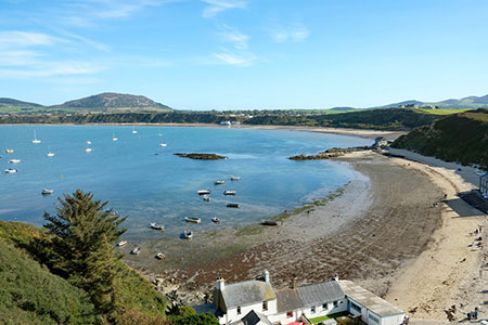
Porth Dinllaen from Morfa Nefyn
Llyn Peninsula Walk
Region - Llyn Peninsula
County/Area - Gwynedd - Llyn Peninsula
Author - Lou Johnson
Length - 4.5 miles / 7.3 km Ascent - 300 feet / 91 metres
Time - 2 hours 30 minutes Grade - easy
Maps 

| Ordnance Survey Explorer 253 | Sheet Map | 1:25k | BUY |
| Anquet OS Explorer 253 | Digital Map | 1:25k | BUY |
Walk Route Description
Click image to see photo description.
This Llŷn Peninsula walk from Morfa Nefyn explores a section of the North Wales Coast Path around the headland of Trwyn Porth Dinllaen. The route offers easy walking and fine views with the opportunity to visit Tŷ Coch pub behind the beach of Porth Dinllaen.
The start is the large National Trust car park behind the beach at Morfa Nefyn (grid ref. SH282408). Note that there are public toilets at the far end from the entrance. After parking return to the exit and turn right along the road (Lon Golff) and continue to the Golf Course Club entrance. Just before the club house, turn left and follow the footpath across the right-hand edge of fields south to reach a track after 600 metres (grid ref. SH278404).
Turn right along the track to Porth Dinllaen farm and the adjacent caravan site. Just past a pond on the left, turn right along a track and continue past the caravans on your left to pass between fields to reach the golf course. Before reaching the course, turn left and follow the path along the right-hand edge of the field. Continue ahead into another field and follow the track down to the sea keeping the field boundary on your right. Reaching a footbridge (on your left) at Aber Geirch, turn right to join the waymarked Wales Coast Path (grid ref. SH267405).
An initial climb leads through a metal kissing gate from where you follow the cliff top path with the golf course to your right. Notices warn you about taking care on this section. The path is easy to follow with white topped posts marking the route. As you make progress the headland of Trwyn Porth Dinllaen comes into view with Yr Eifl the highest hill ahead. The path skirts Borth Wen beach before passing beside a fairway. The path then climbs around a rocky inlet to run parallel to a track on your right. A short climb brings you to the National Coastwatch observation point.
Continue following the path nearest the sea with a view across the bay opening up ahead. Pass in front of the lifeboat station where the path drops down to the sea. The path is rocky in places and there are several paths off to the right. Keep straight ahead to reach the row of cottages at Porth Dinllaen which includes the Tŷ Coch pub. Just past the pub, turn right up a concrete track. Reaching a T-junction turn left following the fingerpost for the Wales Coast Path. The track is the one passed earlier and should be followed through the golf course to reach the club house. Go through the imposing gates and follow the road back to the start.
Other walks nearby
| Walk 3381 | Carn Fadryn Hillfort | easy | 1.5 miles |
| Walk 1796 | Garn Bach & Carn Fadryn | easy/mod | 5.0 miles |
| Walk 3044 | The Rivals (Yr Eifl) from Llithfaen | moderate | 4.5 miles |
| Walk 3374 | Porth y Nant & Nant Gwrtheryn Circular | easy/mod | 3.5 miles |
| Walk 1762 | Pwllheli, Llanbedrog & Abersoch | easy/mod | 9.0 miles |
| Walk 3382 | Llanbedrog Headland Circular | easy | 2.5 miles |
| Walk 3371 | Mynydd Cilan from Hell's Mouth | moderate | 7.3 miles |
| Walk 3375 | Mynydd Penarfynydd from Rhiw | easy | 3.3 miles |
| Walk 3378 | Gyrn Goch, Gyrn Ddu & Bwlch Mawr | mod/hard | 6.5 miles |
| Walk 3339 | Mynydd Anelog & the Whistling Sands | easy | 4.5 miles |
Recommended Books & eBooks
Snowdonia: 30 Low-level and easy walks - North
 Guidebook describing 30 walks in Snowdonia, Wales. Routes are mostly low level and on clear paths and showcase the region's beautiful scenery and rich history and culture. Part of a 2-volume set, this northern volume includes the Snowdon area, the Ogwen and Conwy Valleys, Betws-y-Coed, Beddgelert, Ffestiniog and the coast.
More information
Snowdonia: 30 Low-level and easy walks - South
 Guidebook describing 30 walks in Snowdonia, Wales. Routes are mostly low level and on clear paths and showcase the region's beautiful scenery and rich history and culture. Part of a 2-volume set, this southern volume includes Trawsfynydd, Bala, Dolgellau, Machynlleth, the Harlech Coast and the valleys of the Mawddach and Dyfi.
More information
Messaging & Social Media
Message Walking Britain and follow the latest news.

Mountain Weather
Stay safe on the mountains with detailed weather forecasts - for iOS devices or for Android devices.