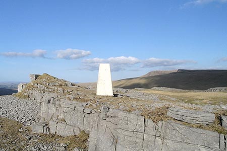
Carreg yr Ogof & Bannau Sir Gaer from Llanddeusant
Brecon Beacons/Bannau Brycheiniog Walk
Nat Park - Brecon Beacons - Brecon Beacons West
County/Area - Carmarthenshire
Author - Lou Johnson
Length - 6.7 miles / 10.9 km Ascent - 1800 feet / 545 metres
Time - 5 hours 10 minutes Grade - moderate
Maps 

| Ordnance Survey Explorer OL12 | Sheet Map | 1:25k | BUY |
| Anquet OS Explorer OL12 | Digital Map | 1:25k | BUY |
| Ordnance Survey Landranger 160 | Sheet Map | 1:50k | BUY |
| Anquet OS Landranger 160 | Digital Map | 1:50k | BUY |
Walk Route Description
Click image to see photo description.
This Brecon Beacons walk explores the area in the western part of the National Park known as Black mountain. The route includes an interesting mix of scenery with limestone pavements and outcrops during the first part of the walk to the summit of Carreg yr Ogof. As you progress along the route you encounter the red sandstone escarpment that many people associate with this National Park as you explore Bannau Sir Gaer where Lyn y Fan Fach lies 600 feet below.
The start is the village of Llanddeusant (grid ref. SN776244) where parking options are very limited. To start the walk, follow the lane between the church and church yard and head west. A track leads off right to the Youth Hostel. Take the next narrow lane on the left walking south into a valley. Cross the river bridge and continue walking uphill. After 400 metres, you pas the entrance to Gellyfron Farm on your right. Continue ahead up the track to reach Open Access Land (grid ref. SN780231).
The onward route follows part of the Beacons Way, which is indistinct in places). However, by heading south you soon reach a small valley containing the stream marked as Nant yr Ysgwydd on OS maps. The route heads up this shallow valley to reach the limestone outcrops that form the summit of Carreg yr Ogof topped by a trig point (grid ref. SN777214). The area around the summit was once quarried and there is plenty of evidence of the underlying limestone.
The next part of route is across pathless moorland terrain. The direction to follow is due east and at first you descend to a broad col at grid ref. SN787213 and you should aim for the highest point of this col. Continue in an easterly direction climbing more steeply over the flank of Waun Lefrith to reach the sandstone escarpment of Bannau Sir Gaer (grid ref. SN798214) from where you gaze down to Llyn y Fan Fach far below.
Turn left along the edge of the escarpment (with the lake on your right. You are now on another section of the Beacons Way. Initially the path is clear and reaching a path junction (grid ref. SN796219), ignore the left-hand path and continue your descent in a northerly direction. Initially the path veers northeast and then swings round to follow its generally northerly route. Your descent continues down the east side of the Garwnant Valley to exit Open Access Land (grid ref. SN792238) at some sheepfolds.
Stay on the Beacons Way as you descend through a wooded area to reach a river. Bear left along the river (river on your right) to reach a lane (grid ref. SN791240). Bear right down the lane, cross the river and then keep left when a lane comes in from the right. Continue along the lane for 1.6 kilometres to return to the start.
Editor's Note - probably the best option for this walk is to stay overnight at the Llanddeusant Youth Hostel which solves the problem with parking in this village.
Other walks nearby
| Walk 3559 | Picws Du & Llyn y Fan Fach from near Llanddeusant | moderate | 5.3 miles |
| Walk 2194 | Mynydd y Llan & source of the Usk | easy/mod | 6.7 miles |
| Walk 3563 | Fan Brycheiniog and Picws Du | moderate | 7.1 miles |
| Walk 2645 | Fan Gyhirych & Fan Bwlch Chwyth, Fforest Fawr | moderate | 8.0 miles |
| Walk 2646 | Fan Nedd & Fan Bwlch Chwyth, Fforest Fawr | moderate | 7.0 miles |
| Walk 2647 | Fan Gyhirych, Fan Nedd & Fan Bwlch Chwyth | moderate | 10.0 miles |
| Walk 2643 | Fan Frynych & Fan Llia, Fforest Fawr | moderate | 8.0 miles |
| Walk 3205 | Carnau Gwynion from Ystradfellte | easy | 4.0 miles |
| Walk 3206 | Ystradfellte Waterfalls Walk | moderate | 9.2 miles |
| Walk 2641 | Fan Fawr & Fan Frynych, Fforest Fawr | moderate | 6.5 miles |
Recommended Books & eBooks
Walking on the Brecon Beacons
 45 circular day walks are described in this guidebook to the Brecon Beacons National Park. From west to east, Mynydd Du, Fforest Fawr, the Brecon Beacons and the Black Mountains these mountain and valley routes offer many options, highlighting the natural features. The walks described explore dramatic waterfalls, wooded gorges and upland valleys.
More information
Walking in Carmarthenshire
 Guidebook to 30 walking routes (2 to 10 miles) in Carmarthenshire, south Wales, including sections of Carmarthenshire Coast Path. Walks for all abilities, including coastal, river, forest and hill walks in Cambrian Mountains, Tywi Valley, Y Mynydd Du (Black Mountains) and Brecon Beacons. Easy access from Bristol, Cardiff and Swansea.
More information
Messaging & Social Media
Message Walking Britain and follow the latest news.

Mountain Weather
Stay safe on the mountains with detailed weather forecasts - for iOS devices or for Android devices.