Cefn Hill & Vagar Hill - Golden Valley
Herefordshire Walk
County/Area - Herefordshire
Author - Lou Johnson
Length - 5.5 miles / 8.9 km Ascent - 700 feet / 212 metres
Time - 3 hours 30 minutes Grade - easy/mod
Maps 

| Ordnance Survey Explorer OL13 | Sheet Map | 1:25k | BUY |
| Anquet OS Explorer OL13 | Digital Map | 1:25k | BUY |
Walk Route Description
Click image to see photo description.
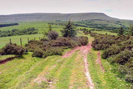
This short but rewarding walk explores two ridges of hills lying between the Wye Valley and the Black Mountains in the Brecon Beacons National Park. The route offers some excellent views across beautiful Herefordshire countryside which forms part of the Golden Valley. A longer version of this walk can be found at Walk 1950.
The start is New House (grid ref. SO267401) where space is available at the entrance to New House Wood for a couple of cars. After parking follow the track into New House Wood. Stay on the main track to a junction. Ignore the track on the right. Continue for 25 metres to a footbridge and follow a path through conifers to exit onto Cefn Hill Common. A grassy rising path leads to the summit which offers an excellent view to Hay Bluff.
Continue across the common and descend on the grassy path for two kilometres to reach a junction of bridleways (grid ref. SO282376). Bear left, cross a stile and follow the path downhill to reach a lane by Llanrosser Chapel (grid ref. SO289377). Turn left and then right at the first junction. Continue to the entrance to Pike's Farm (grid ref. SO292381).
Turn right onto a track and almost immediately cross the stile on your left. Walk half-left across the field to the far right-hand corner and exit onto a lane. Cross the road to a fingerpost and adjacent information board. Cross the adjacent stile onto Vagar Hill Common. Follow the grassy path for 120 metres and fork left and head uphill to the highest point. As you make progress uphill veer towards the right-hand edge of the common. Continue along a walled path to the right of the abandoned Gils Farm and continue along a rough grassy track to a gate (grid ref. SO267396) marking the northern end of the common.
Continue ahead and descend from Vagar Hill. After a kilometre you reach a lane. Turn right and follow the lane back to the start.
Other walks nearby
| Walk 1238 | Hay Bluff & Twmpa Circular | moderate | 6.0 miles |
| Walk 1660 | Craswall Priory & Hay Bluff | easy/mod | 6.0 miles |
| Walk 1950 | Golden Valley - Hardwicke to Dorstone | moderate | 11.4 miles |
| Walk 2179 | Merbach Hill | easy/mod | 6.5 miles |
| Walk 3204 | Hay Bluff & Twmpa | moderate | 10.3 miles |
| Walk 2935 | Llanthony Priory from Capel-y-ffin | easy/mod | 7.7 miles |
| Walk 3622 | Llanthony Priory from Longtown | mod/hard | 7.0 miles |
| Walk 1237 | Cwmyoy & Hatterrall Hill from Llanthony Priory | moderate | 10.0 miles |
| Walk 3203 | Vale of Ewyas from Llanthony Abbey | moderate | 10.7 miles |
| Walk 3342 | The Hatterall Ridge from Llanthony Priory | very hard | 10.0 miles |
Recommended Books & eBooks
No suggestions for this area.Messaging & Social Media
Message Walking Britain and follow the latest news.

Mountain Weather
Stay safe on the mountains with detailed weather forecasts - for iOS devices or for Android devices.