Farley Mount Circular
Hampshire Walk
County/Area - Hampshire
Author - Lou Johnson
Length - 6.5 miles / 10.6 km Ascent - 600 feet / 182 metres
Time - 3 hours 50 minutes Grade - easy/mod
Maps 

| Ordnance Survey Explorer 131 | Sheet Map | 1:25k | BUY |
| Anquet OS Explorer 131 | Digital Map | 1:25k | BUY |
Walk Route Description
Click image to see photo description.
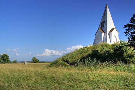
A Hampshire walk exploring Farley Mount Country Park which lies west of Winchester. The area consists of beautiful rolling downland and woodland. The walk also includes the viewpoint of Farley Mount with its folly in memory of a horse. The undulating route includes a section of the Clarendon Way which links Winchester and Salisbury.
The start is the Farley Mount car park (grid ref. SU409293). If the car park is full there are two more convenient places to park in the vicinity. After parking walk to the far end of the car park and take the path leading to the road. Cross the road and follow the clear path opposite. You are now following the Clarendon Way. After 500 metres turn left on a path leading up to Farley Mount which offers excellent views as far afield as the Isle of Wight in clear weather. The Monument has an informative plaque explaining the history.
Retrace you steps back to the main path and turn left and almost immediately fork right on a grassy path. Continue for 500 metres to a junction with a restricted byway turning left (grid ref. SU398291). Bear right at this junction and continue following the Clarendon Way down to a lane (grid ref. SU390297). Just before the lane turn left and follow the clear path between trees. Follow the path as it turns left (still following the Clarendon Way). The onwards path passes through a wood. Exiting the wood, the path veers half-left and follows the course of a Roman Road for just under two kilometres. Keep ahead where the Clarendon Way turns right, pass Hoplands Farm where you join a lane and continue for 600 metres beyond the farm to reach a track on the left (grid ref SU368301).
Turn sharp left and follow the byway through Parnholt Wood. Continue to a four-way fingerpost (grid ref. SU391284) where you turn left. After a kilometre you reach a junction with the Clarendon Way passed earlier in the walk. Turn right and retrace you steps back to the start.
Other walks nearby
| Walk 2383 | Upham & Owslebury Circular | easy/mod | 6.5 miles |
| Walk 3324 | Cheriton Mill & Tichborne from Cheriton | easy | 5.7 miles |
| Walk 1964 | Abbotstone from Old Alresford | easy | 5.1 miles |
| Walk 1034 | Beacon and Old Winchester Hills on the South Downs | moderate | 10.5 miles |
| Walk 3550 | Ashurst Circular | easy | 3.3 miles |
| Walk 3615 | Ashurst (Busketts) Circular | easy | 3.4 miles |
| Walk 2662 | Beacon Hill and Warnford | easy/mod | 6.0 miles |
| Walk 2710 | Old Winchester Hill from Exton | easy/mod | 5.5 miles |
| Walk 3547 | Eyeworth Pond & Ashley Cross from Fritham | easy | 4.4 miles |
| Walk 1612 | Lyndhurst Circular | easy/mod | 7.5 miles |
Recommended Books & eBooks
Walking Hampshire's Test Way
 Guidebook to walking the 71km (44 mile) Test Way in Hampshire from high on the chalk downs of Inkpen Beacon to the Eling Tide Mill near Southampton Water. Following the beautiful, crystal clear River Test, it passes picturesque villages and fascinating historic sites. Also includes 15 day walks to explore this lovely part of pastoral England.
More information
Messaging & Social Media
Message Walking Britain and follow the latest news.

Mountain Weather
Stay safe on the mountains with detailed weather forecasts - for iOS devices or for Android devices.