Lightspout Hollow, Pole Bank & Ashes Hollow
Shropshire Hills Walk
Region - Shropshire Hills
County/Area - Shropshire
Author - Lou Johnson
Length - 7.3 miles / 11.9 km Ascent - 1500 feet / 455 metres
Time - 5 hours 10 minutes Grade - moderate
Maps 

| Ordnance Survey Explorer 217 | Sheet Map | 1:25k | BUY |
| Anquet OS Explorer 217 | Digital Map | 1:25k | BUY |
Walk Route Description
Click image to see photo description.
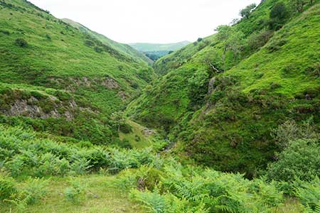
This walk from Carding Mill Valley near Church Stretton in the Long Mynd offers excellent walking in valleys and across the moors. The route ascends through Lightspout Hollows passing a waterfall as you climb. Reaching open moorland, the walk continues to Pole Bank (516 metres) from where there are superb views into Wales. The descent follows a twisting path down Ashes Hollow to Little Stretton followed by an undulating path back to the start.
The start is the top car park in Carding Mill Valley (grid ref. SO4419480 which is located uphill beyond the main car park and at the limit of vehicular access. After parking walk up the valley track. After 500 metres you reach a path junction (grid ref. SO436951). Turn left up Lightspout Hollow to climb steadily soon passing Lightspout waterfall. Continue uphill with the path climbing out of the valley to a junction (grid ref. SO428954) where you keep left and continue up open moorland and a gravel track. Cross the track to a marker post and follow the clear path (Jack Mytton Way) to a car park and lane (grid ref. SO421953).
Cross the lane and take the broad path opposite and continue for a kilometres to reach Pole Bank with its OS trig column and wonderful views. There is also a toposcope proving details of the main highlights of the view. To continue retrace your steps downhill for 240 metres and turn right on along a wide gravel path heading downhill. Reaching a road, turn left and then right onto the first footpath by a marker post (grid ref. SO421946).
The clear path descends into Ashes Hollow, a deep valley between steep hillsides. Keep to the main path in the valley floor and after four kilometres the path leads to a tarmac lane with an adjacent ford (grid ref. SO441920). Turn left down the lane and after a few metres turn left at a fingerpost to join a rising path onto the edge of the valley. The onward path then descends towards a road at Crossbanks (grid ref. SO446930). Leave the road immediately by taking the path on the left. The snaking path climbs into open access land before descending to a stream in Townbrook Valley. Do not turn up the valley but continue ahead to reach Burway Road. Turn left across a cattle grid and then veer right down a track. Continue along this track into Carding Mill Valley. Bear left up the valley back to the start passing a tea room on your left.
Other walks nearby
| Walk 3308 | Ragleth and the Long Mynd | mod/hard | 11.0 miles |
| Walk 3449 | Ragleth, the Long Mynd & Ratlinghope | hard | 18.0 miles |
| Walk 1374 | Lightspout Waterfall and Pole Bank | easy/mod | 5.8 miles |
| Walk 1321 | Caer Caradoc & Hope Bowder Hill | moderate | 9.0 miles |
| Walk 3048 | Caer Caradoc & The Lawley | moderate | 10.0 miles |
| Walk 1097 | Caer Caradoc | easy/mod | 3.5 miles |
| Walk 1844 | The Portway & Betchcott Hill from Picklescott | easy/mod | 5.0 miles |
| Walk 2745 | Betchcott Hills & Pole Bank | moderate | 9.0 miles |
| Walk 1205 | Adstone Hill, Medlicott and the Long Mynd | moderate | 9.5 miles |
| Walk 2054 | Linley Hill & Beeches from Wentnor | easy/mod | 7.0 miles |
Recommended Books & eBooks
Hillwalking in Shropshire
 Guidebook to 32 walking routes in Shropshire in the West Midlands. The routes range from 3 miles (5km) to 12 miles (19km), taking in highlights such as The Wrekin, Wenlock Edge, Long Mynd and Stiperstones, Castle Ring and Bury Ditches. Many routes start near delightful towns and villages including Church Stretton, Ludlow and Bishops Castle.
More information
Messaging & Social Media
Message Walking Britain and follow the latest news.

Mountain Weather
Stay safe on the mountains with detailed weather forecasts - for iOS devices or for Android devices.