Walk 2159 - printer friendly version
Lightspout Hollow, Pole Bank & Ashes Hollow Walk
Author - Lou Johnson
Length - 7.3 miles / 11.9 km
Ascent - 1500 feet / 455 metres
Grade - moderate
Start - OS grid reference SO441948
Lat 52.5481640 + Long -2.8257900
Postcode SY6 6JG (approx. location only)
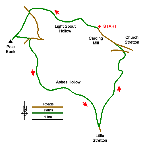
This walk from Carding Mill Valley near Church Stretton in the Long Mynd offers excellent walking in valleys and across the moors. The route ascends through Lightspout Hollows passing a waterfall as you climb. Reaching open moorland, the walk continues to Pole Bank (516 metres) from where there are superb views into Wales. The descent follows a twisting path down Ashes Hollow to Little Stretton followed by an undulating path back to the start.
The start is the top car park in Carding Mill Valley (grid ref. SO4419480 which is located uphill beyond the main car park and at the limit of vehicular access. After parking walk up the valley track. After 500 metres you reach a path junction (grid ref. SO436951). Turn left up Lightspout Hollow to climb steadily soon passing Lightspout waterfall. Continue uphill with the path climbing out of the valley to a junction (grid ref. SO428954) where you keep left and continue up open moorland and a gravel track. Cross the track to a marker post and follow the clear path (Jack Mytton Way) to a car park and lane (grid ref. SO421953).
Cross the lane and take the broad path opposite and continue for a kilometres to reach Pole Bank with its OS trig column and wonderful views. There is also a toposcope proving details of the main highlights of the view. To continue retrace your steps downhill for 240 metres and turn right on along a wide gravel path heading downhill. Reaching a road, turn left and then right onto the first footpath by a marker post (grid ref. SO421946).
The clear path descends into Ashes Hollow, a deep valley between steep hillsides. Keep to the main path in the valley floor and after four kilometres the path leads to a tarmac lane with an adjacent ford (grid ref. SO441920). Turn left down the lane and after a few metres turn left at a fingerpost to join a rising path onto the edge of the valley. The onward path then descends towards a road at Crossbanks (grid ref. SO446930). Leave the road immediately by taking the path on the left. The snaking path climbs into open access land before descending to a stream in Townbrook Valley. Do not turn up the valley but continue ahead to reach Burway Road. Turn left across a cattle grid and then veer right down a track. Continue along this track into Carding Mill Valley. Bear left up the valley back to the start passing a tea room on your left.
Messaging & Social Media
Message Walking Britain and follow the latest news.

Mountain Weather
Stay safe on the mountains with detailed weather forecasts - for iOS devices or for Android devices.