Canons Ashby Circular
Countryside Walk + Historic House
County/Area - Northamptonshire
Author - Lou Johnson
Length - 5.0 miles / 8.1 km Ascent - 240 feet / 73 metres
Time - 2 hours 40 minutes Grade - easy
Maps 

| Ordnance Survey Explorer 206 | Sheet Map | 1:25k | BUY |
| Anquet OS Explorer 206 | Digital Map | 1:25k | BUY |
Walk Route Description
Click image to see photo description.
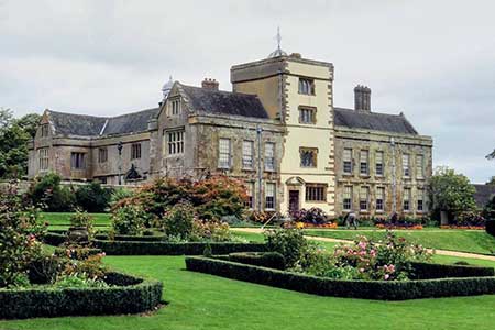
Canons Ashby is a Tudor country house that fell into disrepair and neglect before the National Trust took over in 1981. The house and gardens were gradually restored to their former glory and today the house and gardens are popular with visitors. The route starts from the Canon Ashby's car park (grid ref. SP576505) and then explores the Northamptonshire countryside surrounding the house.
After parking exit the car park and return to the road. Turn right and continue for 300 metres to turn left at the first footpath sign. Head straight across the field and pass through a gap in the fence. Maintain direction across the next field towards the far left-hand corner and exit onto a lane (grid ref. SP576500). Go straight across to the gate opposite to join the continuing path. Pass through three gates to reach a gate which leads into Oxford Lan (grid ref. SP583505). Turn left along this enclosed track. And walk north to reach a lane.
Cross the lane and continue north along the left-hand edge of the field. The route briefly passes through trees before following the edge of woodland to reach a road junction (grid ref. SP578525). Turn left, keep ahead at the junction and after a further 350 metres turn left onto a signed footpath. Pass beside the metal barriers and follow the path beside a hedge to the end of the field and a track. Turn right along the track for 300 metres to the end of the field. Turn left and follow the path south with a hedge on your left. Stay on the path to the end of the field with woodland ahead. Turn right along the field edge and follow the path when it turns left at a hedge corner. Cross the next field with a hedge on your left. Entering a large field, bear left and follow the edge of the field with hedge on your left Just after the path curves right (grid ref. SP, fork left across grass to reach a road. Turn left and return to the car park at Canons Ashby.
Other walks nearby
| Walk 3611 | Ashby Gorse from Moreton Pinkney | easy | 5.7 miles |
| Walk 3090 | Woodford Halse, Hellidon & Badby circular | moderate | 13.8 miles |
| Walk 1794 | Litchborough & Farthingstone Circular | easy/mod | 6.0 miles |
| Walk 1790 | Byfield, Aston le Walls & Boddington Reservoir | easy/mod | 8.2 miles |
| Walk 1825 | Chipping Warden, Thorpe Mandeville, Culworth Circular | easy/mod | 10.0 miles |
| Walk 1070 | Hellidon & Priors Marston | easy | 5.7 miles |
| Walk 3701 | Upper Boddington Circular | easy | 5.5 miles |
| Walk 2276 | Oxford Canal & Stoneton | easy/mod | 7.0 miles |
| Walk 3252 | Wardington & Cropredy from Chacombe | easy/mod | 7.7 miles |
| Walk 3713 | Cropredy & Chipping Warden Circular | easy/mod | 8.6 miles |
Recommended Books & eBooks
No suggestions for this area.Messaging & Social Media
Message Walking Britain and follow the latest news.

Mountain Weather
Stay safe on the mountains with detailed weather forecasts - for iOS devices or for Android devices.